Santa Cecilia geodata
Santa Cecilia (Guanajuato) is a populated place; located in Mexico in America/Mexico_City (GMT-6) time zone. With population of 700 people, there are 12436 cities with bigger population in this country. Compared to other cities in Mexico, 75.4% of cities are located further ↓South; 71.3% of cities are located further →East and 70.2% of cities have lower elevation than Santa Cecilia. Note1


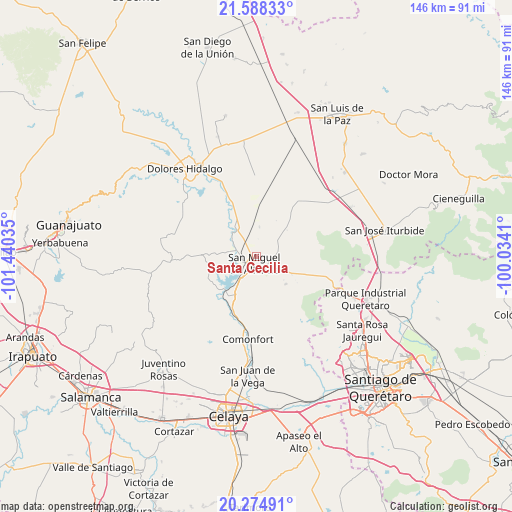
Santa Cecilia GPS coordinates[2]
20° 55' 59.016" North, 100° 44' 13.992" West
| Map corner | latitude | longitude |
|---|---|---|
| Upper-left | 21.58833°, | -101.44035° |
| Center: | 20.93306°, | -100.73722° |
| Lower-right: | 20.27491°, | -100.0341° |
| Map W x H: | 146×146 km | = 90.7×90.7mi |
| max Lat: | 32.7° ⇑24.6% North |
| Santa Cecilia: | 20.93306° |
| min Lat: | ⇓75.4% South 14.53588° |
| min Long | Santa Cecilia | max Long |
| -117.105° | -100.73722° | -86.73105° |
| W 28.7%⇐ | ⇒71.3% E |
Elevation
Elevation of Santa Cecilia is 1927 m = 6322 ft, and this is 673.3 m = 2209 ft above average elevation for this country.
| Max E: |
3497 m = 11473 ft | 29.8% |
| Santa Cecilia | 1927 m 6322 ft | |
| Avg. | 1253.7 m = 4113 ft | |
Min E: |
-1 m = -3 ft | 70.2% |
See also: Mexico elevation on elevation.city.
Geographical zone
Santa Cecilia is located in North Torrid zone (between Equator and Tropic of Cancer). Distance of this Northern Tropic circle is 278.4 km =173 mi to North.| Distance of | km | miles | from Santa Cecilia |
|---|---|---|---|
| North Pole | 7679.5 | 4771.8 | to North |
| Arctic Circle | 5073.6 | 3152.6 | to North |
| Tropic Cancer | 278.4 | 173 | to North |
| Equator | 2327.5 | 1446.2 | to South |


Nearby cities:
15 places around Santa Cecilia: (largest is in red/bold)
• Cañajo
7.9 km =4.9 mi,  126°
126°
• Colonia San Luis Rey
0.3 km =0.2 mi,  22°
22°
• Esperanza
5.2 km =3.2 mi,  257°
257°
• Francisco Villa [Fraccionamiento]
0.7 km =0.4 mi,  32°
32°
• Insurgentes
0.7 km =0.4 mi,  357°
357°
• La Cieneguita
5.6 km =3.5 mi,  285°
285°
• La Lomita
0.6 km =0.4 mi, 18°
• Lomas de San José
4 km =2.5 mi,  304°
304°
• Los López
5.2 km =3.2 mi,  270°
270°
• Montes de Loreto
0.3 km =0.2 mi,  113°
113°
• Nigromante
5.5 km =3.4 mi,  305°
305°
• Palmita de Landeta
4 km =2.5 mi,  116°
116°
• San Miguel Viejo
5.3 km =3.3 mi,  238°
238°
• San Miguel de Allende
2.1 km =1.3 mi,  199°
199°
• Santa Teresita de Don Diego
7.3 km =4.5 mi,  216°
216°
Sources, notices
• [Note1] Compared only with cities in Mexico existing in our database
• [Src1] Map data: © OpenStreetMap contributors (CC-BY-SA)
• [Src2] Other city data from geonames.org with taken over terms of usage.
• [Src3] Geographical zone / Annual Mean Temperature by Robert A. Rohde @ Wikipedia
