San Isidro Chinantilla geodata
San Isidro Chinantilla (Oaxaca) is a populated place; located in Mexico in America/Mexico_City (GMT-6) time zone. With population of 694 people, there are 12543 cities with bigger population in this country. Compared to other cities in Mexico, 80.4% of cities are located further ↑North; 81.1% of cities are located further ←West and 82.3% of cities have higher elevation than San Isidro Chinantilla. Note1
Current local time in San Isidro Chinantilla:
08:35 AM, WednesdayDifference from your time zone: hours


San Isidro Chinantilla GPS coordinates[2]
17° 49' 5.016" North, 96° 14' 18.996" West
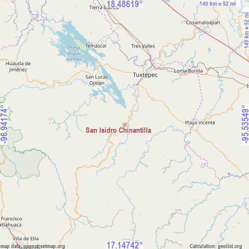
| Map corner | latitude | longitude |
|---|---|---|
| Upper-left | 18.48619°, | -96.94174° |
| Center: | 17.81806°, | -96.23861° |
| Lower-right: | 17.14742°, | -95.53549° |
| Map W x H: | 148.9×148.9 km | = 92.5×92.5mi |
| max Lat: | 32.7° ⇑80.4% North |
| San Isidro Chinantilla: | 17.81806° |
| min Lat: | ⇓19.6% South 14.53588° |
| min Long | San Isidro Chin | max Long |
| -117.105° | -96.23861° | -86.73105° |
| W 81.1%⇐ | ⇒18.9% E |
Elevation
Elevation of San Isidro Chinantilla is 67 m = 220 ft, and this is 1186.7 m = 3893 ft below average elevation for this country.
| Max E: |
3497 m = 11473 ft | 82.3% |
| Avg. | 1253.7 m = 4113 ft | |
| San Isidro Chinantilla | 67 m = 220 ft | |
Min E: |
-1 m = -3 ft | 17.7% |
See also: Mexico elevation on elevation.city.
Geographical zone
San Isidro Chinantilla is located in North Torrid zone (between Equator and Tropic of Cancer). Distance of this Northern Tropic circle is 624.7 km =388.2 mi to North.| Distance of | km | miles | from San Isidro Chinantilla |
|---|---|---|---|
| North Pole | 8025.9 | 4987.1 | to North |
| Arctic Circle | 5420 | 3367.8 | to North |
| Tropic Cancer | 624.7 | 388.2 | to North |
| Equator | 1981.2 | 1231.1 | to South |


Nearby cities:
15 places around San Isidro Chinantilla: (largest is in red/bold)
• Agua de Pescadito
12.3 km =7.6 mi,  311°
311°
• Arroyo Frijol
13 km =8.1 mi,  25°
25°
• Arroyo de Banco
11.7 km =7.3 mi,  261°
261°
• Cerro Armadillo Grande
9.1 km =5.7 mi, 305°
• Cerro Concha
5.4 km =3.4 mi,  70°
70°
• Cerro Marín (Monte Flor)
4 km =2.5 mi,  238°
238°
• La Gran Lucha
9.1 km =5.7 mi, 239°
• La Rinconada
8 km =5 mi,  147°
147°
• Paso Nuevo la Hamaca
6.6 km =4.1 mi,  167°
167°
• San Isidro Naranjal
14.2 km =8.8 mi,  56°
56°
• San Pedro Ozumacín
15.6 km =9.7 mi, 174°
• Santa Fe y la Mar
10 km =6.2 mi,  234°
234°
• Santa María Jacatepec
5.5 km =3.4 mi, 30°
• Valle Nacional
8.2 km =5.1 mi, 234°
• Vega del Sol
2.5 km =1.6 mi,  112°
112°
Sources, notices
• [Note1] Compared only with cities in Mexico existing in our database
• [Src1] Map data: © OpenStreetMap contributors (CC-BY-SA)
• [Src2] Other city data from geonames.org with taken over terms of usage.
• [Src3] Geographical zone / Annual Mean Temperature by Robert A. Rohde @ Wikipedia
