Bochil geodata
Bochil (Chiapas) is a seat of a second-order administrative division; located in Mexico in America/Mexico_City (GMT-6) time zone. With population of 12,404 people, there are 783 cities with bigger population in this country. Compared to other cities in Mexico, 88.9% of cities are located further ↑North; 89.3% of cities are located further ←West and 55.9% of cities have higher elevation than Bochil. Note1


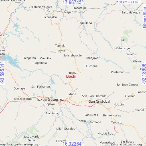
Bochil GPS coordinates[2]
16° 59' 46.5" North, 92° 53' 31.848" West
| Map corner | latitude | longitude |
|---|---|---|
| Upper-left | 17.66745°, | -93.59531° |
| Center: | 16.99625°, | -92.89218° |
| Lower-right: | 16.32264°, | -92.18906° |
| Map W x H: | 149.5×149.5 km | = 92.9×92.9mi |
| max Lat: | 32.7° ⇑88.9% North |
| Bochil: | 16.99625° |
| min Lat: | ⇓11.1% South 14.53588° |
| min Long | Bochil | max Long |
| -117.105° | -92.89218° | -86.73105° |
| W 89.3%⇐ | ⇒10.7% E |
Elevation
Elevation of Bochil is 1162 m = 3812 ft, and this is 91.7 m = 301 ft below average elevation for this country.
| Max E: |
3497 m = 11473 ft | 55.9% |
| Avg. | 1253.7 m = 4113 ft | |
| Bochil | 1162 m = 3812 ft | |
Min E: |
-1 m = -3 ft | 44.1% |
See also: Mexico elevation on elevation.city.
Geographical zone
Bochil is located in North Torrid zone (between Equator and Tropic of Cancer). Distance of this Northern Tropic circle is 716.1 km =445 mi to North.| Distance of | km | miles | from Bochil |
|---|---|---|---|
| North Pole | 8117.3 | 5043.9 | to North |
| Arctic Circle | 5511.4 | 3424.6 | to North |
| Tropic Cancer | 716.1 | 445 | to North |
| Equator | 1889.8 | 1174.3 | to South |


Nearby cities:
15 places around Bochil: (largest is in red/bold)
• Ajilhó
5.1 km =3.2 mi,  254°
254°
• Buenavista
8.6 km =5.3 mi,  145°
145°
• Chuchiltón
7.8 km =4.8 mi,  123°
123°
• Chuchiltón Anexo Potobtic Dos
5.2 km =3.2 mi, 118°
• El Copal
4.8 km =3 mi,  228°
228°
• El Ámbar
6.9 km =4.3 mi,  62°
62°
• Jitotol
8.6 km =5.3 mi,  22°
22°
• Majoval
7.2 km =4.5 mi,  91°
91°
• Monte Grande
7.2 km =4.5 mi, 153°
• San Pedro el Achiote (San Pedro Mártir)
4.2 km =2.6 mi,  276°
276°
• San Vicente
5.6 km =3.5 mi,  216°
216°
• Tierra Colorada
3.2 km =2 mi,  310°
310°
• Venustiano Carranza
5.6 km =3.5 mi, 225°
• Yerbabuena Isbontick
7.6 km =4.7 mi,  158°
158°
• Álvaro Obregón
9.7 km =6 mi,  68°
68°
Sources, notices
• [Note1] Compared only with cities in Mexico existing in our database
• [Src1] Map data: © OpenStreetMap contributors (CC-BY-SA)
• [Src2] Other city data from geonames.org with taken over terms of usage.
• [Src3] Geographical zone / Annual Mean Temperature by Robert A. Rohde @ Wikipedia
