Punta de Piedra geodata
Punta de Piedra (Tamaulipas) is a populated place; located in Mexico in America/Monterrey (GMT-6) time zone. With population of 655 people, there are 13244 cities with bigger population in this country. Compared to other cities in Mexico, 90.9% of cities are located further ↓South; 66.7% of cities are located further ←West and 98.7% of cities have higher elevation than Punta de Piedra. Note1


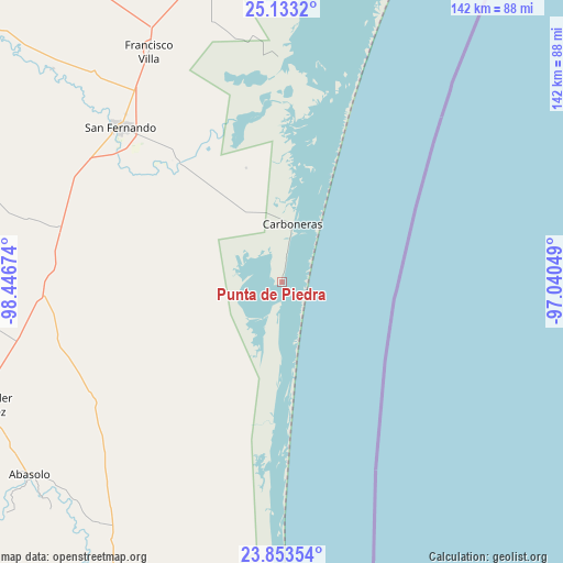
Punta de Piedra GPS coordinates[2]
24° 29' 42" North, 97° 44' 36.996" West
| Map corner | latitude | longitude |
|---|---|---|
| Upper-left | 25.1332°, | -98.44674° |
| Center: | 24.495°, | -97.74361° |
| Lower-right: | 23.85354°, | -97.04049° |
| Map W x H: | 142.3×142.3 km | = 88.4×88.4mi |
| max Lat: | 32.7° ⇑9.1% North |
| Punta de Piedra: | 24.495° |
| min Lat: | ⇓90.9% South 14.53588° |
| min Long | Punta de Piedra | max Long |
| -117.105° | -97.74361° | -86.73105° |
| W 66.7%⇐ | ⇒33.3% E |
Elevation
Elevation of Punta de Piedra is 7 m = 23 ft, and this is 1246.7 m = 4090 ft below average elevation for this country.
| Max E: |
3497 m = 11473 ft | 98.7% |
| Avg. | 1253.7 m = 4113 ft | |
| Punta de Piedra | 7 m = 23 ft | |
Min E: |
-1 m = -3 ft | 1.3% |
See also: Mexico elevation on elevation.city.
Geographical zone
Punta de Piedra is located in North temperate zone (between Tropic of Cancer and the Arctic Circle). Distance of this Northern Tropic circle is 117.7 km =73.1 mi to South.| Distance of | km | miles | from Punta de Piedra |
|---|---|---|---|
| North Pole | 7283.5 | 4525.8 | to North |
| Arctic Circle | 4677.6 | 2906.5 | to North |
| Tropic Cancer | 117.7 | 73.1 | to South |
| Equator | 2723.6 | 1692.4 | to South |


Nearby cities:
15 places around Punta de Piedra: (largest is in red/bold)
• Abasolo
80.2 km =49.8 mi,  232°
232°
• Allende
77.7 km =48.3 mi,  241°
241°
• Carboneras
15 km =9.3 mi,  10°
10°
• Carvajal
2.1 km =1.3 mi, 10°
• División del Norte
45.3 km =28.1 mi,  318°
318°
• El Barrancón del Tío Blas (El Barrancón)
57.9 km =36 mi,  2°
2°
• Emiliano Zapata (Ampliación San Germán)
73.1 km =45.4 mi,  334°
334°
• Guadalupe Victoria
67.6 km =42 mi, 227°
• La Lomita
72.4 km =45 mi, 333°
• La Pesca
78.8 km =49 mi,  182°
182°
• Miguel de la Madrid
79.1 km =49.2 mi, 180°
• Nicolás Bravo
75.8 km =47.1 mi,  223°
223°
• Nuevo Morelos
81 km =50.3 mi, 227°
• Punta de Alambre
6.3 km =3.9 mi, 9°
• San Fernando
56.6 km =35.2 mi,  313°
313°
Sources, notices
• [Note1] Compared only with cities in Mexico existing in our database
• [Src1] Map data: © OpenStreetMap contributors (CC-BY-SA)
• [Src2] Other city data from geonames.org with taken over terms of usage.
• [Src3] Geographical zone / Annual Mean Temperature by Robert A. Rohde @ Wikipedia
