Allende geodata
Allende (Tamaulipas) is a populated place; located in Mexico in America/Monterrey (GMT-6) time zone. With population of 826 people, there are 10586 cities with bigger population in this country. Compared to other cities in Mexico, 90.3% of cities are located further ↓South; 58.4% of cities are located further ←West and 80.3% of cities have higher elevation than Allende. Note1


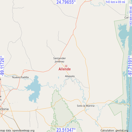
Allende GPS coordinates[2]
24° 9' 23.832" North, 98° 24' 50.868" West
| Map corner | latitude | longitude |
|---|---|---|
| Upper-left | 24.79655°, | -99.11726° |
| Center: | 24.15662°, | -98.41413° |
| Lower-right: | 23.51347°, | -97.71101° |
| Map W x H: | 142.7×142.7 km | = 88.7×88.7mi |
| max Lat: | 32.7° ⇑9.7% North |
| Allende: | 24.15662° |
| min Lat: | ⇓90.3% South 14.53588° |
| min Long | Allende | max Long |
| -117.105° | -98.41413° | -86.73105° |
| W 58.4%⇐ | ⇒41.6% E |
Elevation
Elevation of Allende is 90 m = 295 ft, and this is 1163.7 m = 3818 ft below average elevation for this country.
| Max E: |
3497 m = 11473 ft | 80.3% |
| Avg. | 1253.7 m = 4113 ft | |
| Allende | 90 m = 295 ft | |
Min E: |
-1 m = -3 ft | 19.7% |
See also: Mexico elevation on elevation.city.
Geographical zone
Allende is located in North temperate zone (between Tropic of Cancer and the Arctic Circle). Distance of this Northern Tropic circle is 80 km =49.7 mi to South.| Distance of | km | miles | from Allende |
|---|---|---|---|
| North Pole | 7321.1 | 4549.1 | to North |
| Arctic Circle | 4715.2 | 2929.9 | to North |
| Tropic Cancer | 80 | 49.7 | to South |
| Equator | 2686 | 1669 | to South |


Nearby cities:
15 places around Allende: (largest is in red/bold)
• Abasolo
11.7 km =7.3 mi,  159°
159°
• Barretal
72.6 km =45.1 mi,  263°
263°
• Casas
57.9 km =36 mi,  214°
214°
• Cruillas
67.9 km =42.2 mi,  349°
349°
• Guadalupe Victoria
20.1 km =12.5 mi,  114°
114°
• Guemes
65.7 km =40.8 mi,  246°
246°
• La Soledad
68 km =42.3 mi, 262°
• Nicolás Bravo
23.3 km =14.5 mi,  137°
137°
• Nueva Villa de Padilla
50.9 km =31.6 mi, 256°
• Nuevo Morelos
19.3 km =12 mi,  153°
153°
• Plan de Ayala
72.5 km =45 mi, 260°
• San Carlos
71.4 km =44.4 mi,  311°
311°
• Santander Jiménez
9.8 km =6.1 mi, 313°
• Soto la Marina
48 km =29.8 mi, 153°
• Tampiquito
42.3 km =26.3 mi, 148°
Sources, notices
• [Note1] Compared only with cities in Mexico existing in our database
• [Src1] Map data: © OpenStreetMap contributors (CC-BY-SA)
• [Src2] Other city data from geonames.org with taken over terms of usage.
• [Src3] Geographical zone / Annual Mean Temperature by Robert A. Rohde @ Wikipedia
