La Pesca geodata
La Pesca (Tamaulipas) is a populated place; located in Mexico in America/Monterrey (GMT-6) time zone. With population of 1,764 people, there are 4921 cities with bigger population in this country. Compared to other cities in Mexico, 89.4% of cities are located further ↓South; 66.4% of cities are located further ←West and 99.1% of cities have higher elevation than La Pesca. Note1


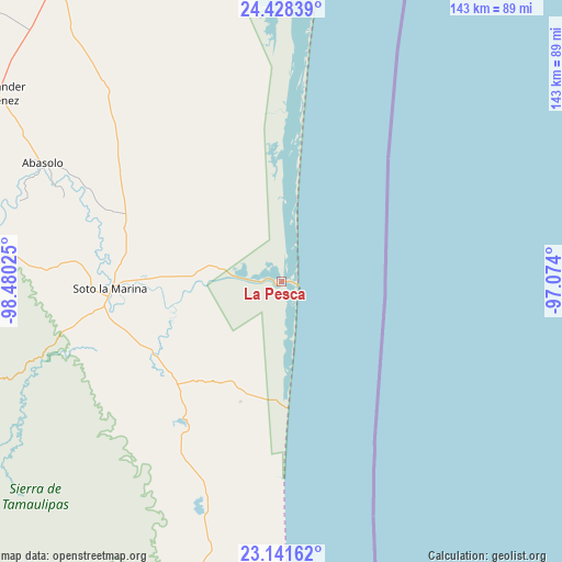
La Pesca GPS coordinates[2]
23° 47' 11.76" North, 97° 46' 37.632" West
| Map corner | latitude | longitude |
|---|---|---|
| Upper-left | 24.42839°, | -98.48025° |
| Center: | 23.7866°, | -97.77712° |
| Lower-right: | 23.14162°, | -97.074° |
| Map W x H: | 143.1×143.1 km | = 88.9×88.9mi |
| max Lat: | 32.7° ⇑10.6% North |
| La Pesca: | 23.7866° |
| min Lat: | ⇓89.4% South 14.53588° |
| min Long | La Pesca | max Long |
| -117.105° | -97.77712° | -86.73105° |
| W 66.4%⇐ | ⇒33.6% E |
Elevation
Elevation of La Pesca is 6 m = 20 ft, and this is 1247.7 m = 4094 ft below average elevation for this country.
| Max E: |
3497 m = 11473 ft | 99.1% |
| Avg. | 1253.7 m = 4113 ft | |
| La Pesca | 6 m = 20 ft | |
Min E: |
-1 m = -3 ft | 0.9% |
See also: Mexico elevation on elevation.city.
Geographical zone
La Pesca is located in North temperate zone (between Tropic of Cancer and the Arctic Circle). Distance of this Northern Tropic circle is 38.9 km =24.2 mi to South.| Distance of | km | miles | from La Pesca |
|---|---|---|---|
| North Pole | 7362.2 | 4574.7 | to North |
| Arctic Circle | 4756.4 | 2955.5 | to North |
| Tropic Cancer | 38.9 | 24.2 | to South |
| Equator | 2644.8 | 1643.4 | to South |


Nearby cities:
15 places around La Pesca: (largest is in red/bold)
• Abasolo
67.7 km =42.1 mi,  296°
296°
• Allende
76.7 km =47.7 mi, 302°
• Barra el Tordo
81.8 km =50.8 mi,  179°
179°
• Carboneras
93.7 km =58.2 mi,  3°
3°
• Carvajal
80.9 km =50.3 mi, 2°
• Guadalupe Victoria
56.8 km =35.3 mi,  305°
305°
• Miguel de la Madrid
2.4 km =1.5 mi,  97°
97°
• Nicolás Bravo
54.5 km =33.9 mi, 296°
• Nuevo Morelos
61.1 km =38 mi,  292°
292°
• Nuevo Progreso
70.1 km =43.6 mi,  194°
194°
• Punta de Alambre
85.1 km =52.9 mi, 2°
• Punta de Piedra
78.8 km =49 mi, 2°
• Santander Jiménez
86.3 km =53.6 mi, 303°
• Soto la Marina
43.5 km =27 mi,  267°
267°
• Tampiquito
42.8 km =26.6 mi,  276°
276°
Sources, notices
• [Note1] Compared only with cities in Mexico existing in our database
• [Src1] Map data: © OpenStreetMap contributors (CC-BY-SA)
• [Src2] Other city data from geonames.org with taken over terms of usage.
• [Src3] Geographical zone / Annual Mean Temperature by Robert A. Rohde @ Wikipedia
