Chalmita geodata
Chalmita (Hidalgo) is a populated place; located in Mexico in America/Mexico_City (GMT-6) time zone. With population of 653 people, there are 13279 cities with bigger population in this country. Compared to other cities in Mexico, 57.3% of cities are located further ↓South; 50.3% of cities are located further →East and 91% of cities have lower elevation than Chalmita. Note1


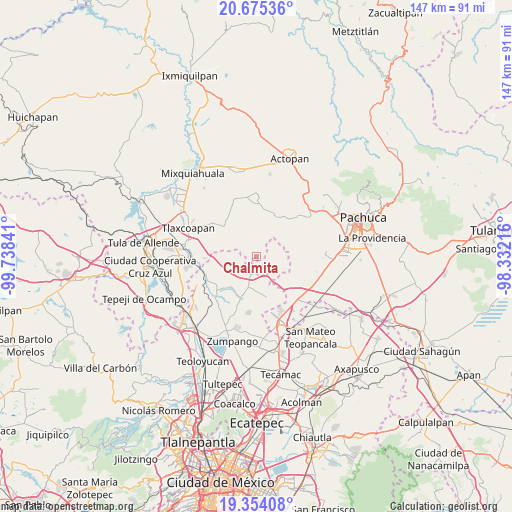
Chalmita GPS coordinates[2]
20° 0' 57.996" North, 99° 2' 7.008" West
| Map corner | latitude | longitude |
|---|---|---|
| Upper-left | 20.67536°, | -99.73841° |
| Center: | 20.01611°, | -99.03528° |
| Lower-right: | 19.35408°, | -98.33216° |
| Map W x H: | 146.9×146.9 km | = 91.3×91.3mi |
| max Lat: | 32.7° ⇑42.7% North |
| Chalmita: | 20.01611° |
| min Lat: | ⇓57.3% South 14.53588° |
| min Long | Chalmita | max Long |
| -117.105° | -99.03528° | -86.73105° |
| W 49.7%⇐ | ⇒50.3% E |
Elevation
Elevation of Chalmita is 2442 m = 8012 ft, and this is 1188.3 m = 3899 ft above average elevation for this country.
| Max E: |
3497 m = 11473 ft | 9% |
| Chalmita | 2442 m 8012 ft | |
| Avg. | 1253.7 m = 4113 ft | |
Min E: |
-1 m = -3 ft | 91% |
See also: Mexico elevation on elevation.city.
Geographical zone
Chalmita is located in North Torrid zone (between Equator and Tropic of Cancer). Distance of this Northern Tropic circle is 380.3 km =236.3 mi to North.| Distance of | km | miles | from Chalmita |
|---|---|---|---|
| North Pole | 7781.5 | 4835.2 | to North |
| Arctic Circle | 5175.6 | 3216 | to North |
| Tropic Cancer | 380.3 | 236.3 | to North |
| Equator | 2225.6 | 1382.9 | to South |


Nearby cities:
15 places around Chalmita: (largest is in red/bold)
• Ajacuba
12.4 km =7.7 mi,  312°
312°
• Colonia Guadalupe los Manantiales
4.5 km =2.8 mi,  214°
214°
• Colonia Juárez
12.1 km =7.5 mi,  259°
259°
• Coyotillos
13 km =8.1 mi, 261°
• Emiliano Zapata (San José Bata)
12.1 km =7.5 mi,  165°
165°
• Hueypoxtla
12.2 km =7.6 mi,  199°
199°
• La Gloria
4.9 km =3 mi,  132°
132°
• Oriental de Zapata
3.4 km =2.1 mi, 173°
• Puerto México
9.7 km =6 mi,  22°
22°
• Pérez de Galeana
11.8 km =7.3 mi,  249°
249°
• San Francisco Zacacalco
11.2 km =7 mi,  150°
150°
• Santa María Ajoloapan
4.5 km =2.8 mi,  192°
192°
• Santiago Tlajomulco
12.9 km =8 mi,  104°
104°
• Tianguistongo
1.2 km =0.7 mi, 196°
• Tlapanaloya
11 km =6.8 mi,  215°
215°
Sources, notices
• [Note1] Compared only with cities in Mexico existing in our database
• [Src1] Map data: © OpenStreetMap contributors (CC-BY-SA)
• [Src2] Other city data from geonames.org with taken over terms of usage.
• [Src3] Geographical zone / Annual Mean Temperature by Robert A. Rohde @ Wikipedia
