Loma Tuza geodata
Loma Tuza (Guerrero) is a populated place; located in Mexico in America/Mexico_City (GMT-6) time zone. With population of 736 people, there are 11874 cities with bigger population in this country. Compared to other cities in Mexico, 84.7% of cities are located further ↑North; 52.5% of cities are located further ←West and 86.3% of cities have lower elevation than Loma Tuza. Note1


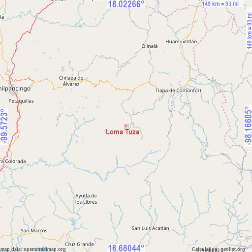
Loma Tuza GPS coordinates[2]
17° 21' 10.008" North, 98° 52' 9.012" West
| Map corner | latitude | longitude |
|---|---|---|
| Upper-left | 18.02266°, | -99.5723° |
| Center: | 17.35278°, | -98.86917° |
| Lower-right: | 16.68044°, | -98.16605° |
| Map W x H: | 149.2×149.2 km | = 92.7×92.7mi |
| max Lat: | 32.7° ⇑84.7% North |
| Loma Tuza: | 17.35278° |
| min Lat: | ⇓15.3% South 14.53588° |
| min Long | Loma Tuza | max Long |
| -117.105° | -98.86917° | -86.73105° |
| W 52.5%⇐ | ⇒47.5% E |
Elevation
Elevation of Loma Tuza is 2289 m = 7510 ft, and this is 1035.3 m = 3397 ft above average elevation for this country.
| Max E: |
3497 m = 11473 ft | 13.7% |
| Loma Tuza | 2289 m 7510 ft | |
| Avg. | 1253.7 m = 4113 ft | |
Min E: |
-1 m = -3 ft | 86.3% |
See also: Mexico elevation on elevation.city.
Geographical zone
Loma Tuza is located in North Torrid zone (between Equator and Tropic of Cancer). Distance of this Northern Tropic circle is 676.5 km =420.4 mi to North.| Distance of | km | miles | from Loma Tuza |
|---|---|---|---|
| North Pole | 8077.6 | 5019.2 | to North |
| Arctic Circle | 5471.7 | 3400 | to North |
| Tropic Cancer | 676.5 | 420.4 | to North |
| Equator | 1929.4 | 1198.9 | to South |


Nearby cities:
15 places around Loma Tuza: (largest is in red/bold)
• Acatepec
5.3 km =3.3 mi,  233°
233°
• Ahuixotitla
8.2 km =5.1 mi,  57°
57°
• Apetzuca
7.6 km =4.7 mi,  148°
148°
• Ayotoxtla
5.8 km =3.6 mi,  37°
37°
• Cacalotepec
4 km =2.5 mi,  333°
333°
• Chichiltepec
7.3 km =4.5 mi,  255°
255°
• El Chirimoyo
2.3 km =1.4 mi,  244°
244°
• Escalerilla Lagunas
3.7 km =2.3 mi, 40°
• Huixolotepec (Huitzolotepec)
4.4 km =2.7 mi,  292°
292°
• Tamaloya
5.7 km =3.5 mi, 57°
• Villa de Guadalupe
5.9 km =3.7 mi, 36°
• Xalpitzáhuac
8.1 km =5 mi,  354°
354°
• Zilacayota
8.7 km =5.4 mi,  130°
130°
• Zontecomapa
4.4 km =2.7 mi,  144°
144°
• Zoquitlán
8.6 km =5.3 mi, 261°
Sources, notices
• [Note1] Compared only with cities in Mexico existing in our database
• [Src1] Map data: © OpenStreetMap contributors (CC-BY-SA)
• [Src2] Other city data from geonames.org with taken over terms of usage.
• [Src3] Geographical zone / Annual Mean Temperature by Robert A. Rohde @ Wikipedia
