Villa de Guadalupe geodata
Villa de Guadalupe (Guerrero) is a populated place; located in Mexico in America/Mexico_City (GMT-6) time zone. With population of 649 people, there are 13347 cities with bigger population in this country. Compared to other cities in Mexico, 84.2% of cities are located further ↑North; 53.1% of cities are located further ←West and 82.6% of cities have lower elevation than Villa de Guadalupe. Note1


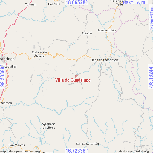
Villa de Guadalupe GPS coordinates[2]
17° 23' 44.016" North, 98° 50' 8.016" West
| Map corner | latitude | longitude |
|---|---|---|
| Upper-left | 18.06528°, | -99.53869° |
| Center: | 17.39556°, | -98.83556° |
| Lower-right: | 16.72338°, | -98.13244° |
| Map W x H: | 149.2×149.2 km | = 92.7×92.7mi |
| max Lat: | 32.7° ⇑84.2% North |
| Villa de Guadalupe: | 17.39556° |
| min Lat: | ⇓15.8% South 14.53588° |
| min Long | Villa de Guadal | max Long |
| -117.105° | -98.83556° | -86.73105° |
| W 53.1%⇐ | ⇒46.9% E |
Elevation
Elevation of Villa de Guadalupe is 2205 m = 7234 ft, and this is 951.3 m = 3121 ft above average elevation for this country.
| Max E: |
3497 m = 11473 ft | 17.4% |
| Villa de Guadalupe | 2205 m 7234 ft | |
| Avg. | 1253.7 m = 4113 ft | |
Min E: |
-1 m = -3 ft | 82.6% |
See also: Mexico elevation on elevation.city.
Geographical zone
Villa de Guadalupe is located in North Torrid zone (between Equator and Tropic of Cancer). Distance of this Northern Tropic circle is 671.7 km =417.4 mi to North.| Distance of | km | miles | from Villa de Guadalupe |
|---|---|---|---|
| North Pole | 8072.9 | 5016.3 | to North |
| Arctic Circle | 5467 | 3397 | to North |
| Tropic Cancer | 671.7 | 417.4 | to North |
| Equator | 1934.2 | 1201.9 | to South |


Nearby cities:
15 places around Villa de Guadalupe: (largest is in red/bold)
• Ahuixotitla
3.4 km =2.1 mi,  95°
95°
• Ayotoxtla
0.2 km =0.1 mi,  188°
188°
• Cacalotepec
5.5 km =3.4 mi,  257°
257°
• El Chirimoyo
8.1 km =5 mi,  224°
224°
• Escalerilla Lagunas
2.3 km =1.4 mi,  211°
211°
• Huixolotepec (Huitzolotepec)
8.2 km =5.1 mi,  248°
248°
• Huiztlatzala
7 km =4.3 mi,  92°
92°
• Loma Tuza
5.9 km =3.7 mi, 216°
• San Juan Bautista Coapala
5.1 km =3.2 mi,  355°
355°
• San Pedro Huitzapula Norte (Huitzapula Norte)
4.7 km =2.9 mi,  42°
42°
• Tamaloya
2.1 km =1.3 mi,  144°
144°
• Xalpitzáhuac
5.5 km =3.4 mi,  306°
306°
• Zapotitlán Tablas
6.6 km =4.1 mi,  61°
61°
• Zilacayota
10.9 km =6.8 mi,  163°
163°
• Zontecomapa
8.4 km =5.2 mi, 187°
Sources, notices
• [Note1] Compared only with cities in Mexico existing in our database
• [Src1] Map data: © OpenStreetMap contributors (CC-BY-SA)
• [Src2] Other city data from geonames.org with taken over terms of usage.
• [Src3] Geographical zone / Annual Mean Temperature by Robert A. Rohde @ Wikipedia
