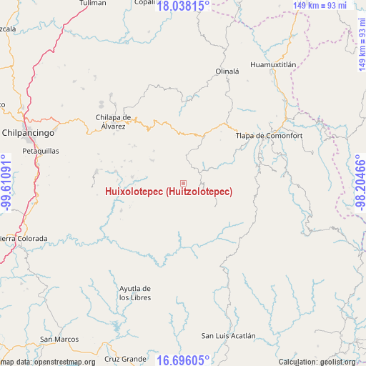
Huixolotepec (Huitzolotepec) geodata
Huixolotepec (Huitzolotepec) (Guerrero) is a populated place; located in Mexico in America/Mexico_City (GMT-6) time zone. With population of 539 people, there are 15751 cities with bigger population in this country. Compared to other cities in Mexico, 84.5% of cities are located further ↑North; 51.8% of cities are located further ←West and 64% of cities have lower elevation than Huixolotepec (Huitzolotepec). Note1
Current local time in Huixolotepec (Huitzolotepec):
08:32 AM, WednesdayDifference from your time zone: hours


Huixolotepec (Huitzolotepec) GPS coordinates[2]
17° 22' 5.988" North, 98° 54' 28.008" West
| Map corner | latitude | longitude |
|---|---|---|
| Upper-left | 18.03815°, | -99.61091° |
| Center: | 17.36833°, | -98.90778° |
| Lower-right: | 16.69605°, | -98.20466° |
| Map W x H: | 149.2×149.2 km | = 92.7×92.7mi |
| max Lat: | 32.7° ⇑84.5% North |
| Huixolotepec (Huitzolotepec): | 17.36833° |
| min Lat: | ⇓15.5% South 14.53588° |
| min Long | Huixolotepec (H | max Long |
| -117.105° | -98.90778° | -86.73105° |
| W 51.8%⇐ | ⇒48.2% E |
Elevation
Elevation of Huixolotepec (Huitzolotepec) is 1801 m = 5909 ft, and this is 547.3 m = 1796 ft above average elevation for this country.
| Max E: |
3497 m = 11473 ft | 36% |
| Huixolotepec (Huitzolotepec) | 1801 m 5909 ft | |
| Avg. | 1253.7 m = 4113 ft | |
Min E: |
-1 m = -3 ft | 64% |
See also: Mexico elevation on elevation.city.
Geographical zone
Huixolotepec (Huitzolotepec) is located in North Torrid zone (between Equator and Tropic of Cancer). Distance of this Northern Tropic circle is 674.7 km =419.2 mi to North.| Distance of | km | miles | from Huixolotepec (Huitzolotepec) |
|---|---|---|---|
| North Pole | 8075.9 | 5018.1 | to North |
| Arctic Circle | 5470 | 3398.9 | to North |
| Tropic Cancer | 674.7 | 419.2 | to North |
| Equator | 1931.2 | 1200 | to South |


Nearby cities:
15 places around Huixolotepec (Huitzolotepec): (largest is in red/bold)
• Acatepec
4.9 km =3 mi,  182°
182°
• Ayotoxtla
8.1 km =5 mi,  69°
69°
• Cacahuatepec
7.1 km =4.4 mi,  295°
295°
• Cacalotepec
3 km =1.9 mi,  50°
50°
• Chichiltepec
4.6 km =2.9 mi,  220°
220°
• El Chirimoyo
3.4 km =2.1 mi,  143°
143°
• Escalerilla Lagunas
6.6 km =4.1 mi,  80°
80°
• Loma Tuza
4.4 km =2.7 mi,  112°
112°
• Mexcalcingo
9.9 km =6.2 mi,  281°
281°
• Tamaloya
9 km =5.6 mi, 81°
• Tonalapa
7.7 km =4.8 mi, 216°
• Villa de Guadalupe
8.2 km =5.1 mi, 68°
• Xalpitzáhuac
7.1 km =4.4 mi,  27°
27°
• Zontecomapa
8.5 km =5.3 mi,  128°
128°
• Zoquitlán
5.3 km =3.3 mi,  236°
236°
Sources, notices
• [Note1] Compared only with cities in Mexico existing in our database
• [Src1] Map data: © OpenStreetMap contributors (CC-BY-SA)
• [Src2] Other city data from geonames.org with taken over terms of usage.
• [Src3] Geographical zone / Annual Mean Temperature by Robert A. Rohde @ Wikipedia
