Cacalotepec geodata
Cacalotepec (Guerrero) is a populated place; located in Mexico in America/Mexico_City (GMT-6) time zone. With population of 755 people, there are 11595 cities with bigger population in this country. Compared to other cities in Mexico, 84.3% of cities are located further ↑North; 52.2% of cities are located further ←West and 64.4% of cities have lower elevation than Cacalotepec. Note1


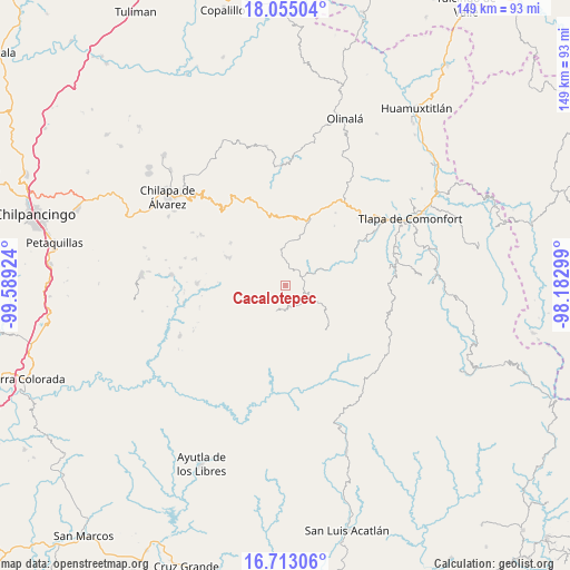
Cacalotepec GPS coordinates[2]
17° 23' 7.008" North, 98° 53' 9.996" West
| Map corner | latitude | longitude |
|---|---|---|
| Upper-left | 18.05504°, | -99.58924° |
| Center: | 17.38528°, | -98.88611° |
| Lower-right: | 16.71306°, | -98.18299° |
| Map W x H: | 149.2×149.2 km | = 92.7×92.7mi |
| max Lat: | 32.7° ⇑84.3% North |
| Cacalotepec: | 17.38528° |
| min Lat: | ⇓15.7% South 14.53588° |
| min Long | Cacalotepec | max Long |
| -117.105° | -98.88611° | -86.73105° |
| W 52.2%⇐ | ⇒47.8% E |
Elevation
Elevation of Cacalotepec is 1812 m = 5945 ft, and this is 558.3 m = 1832 ft above average elevation for this country.
| Max E: |
3497 m = 11473 ft | 35.6% |
| Cacalotepec | 1812 m 5945 ft | |
| Avg. | 1253.7 m = 4113 ft | |
Min E: |
-1 m = -3 ft | 64.4% |
See also: Mexico elevation on elevation.city.
Geographical zone
Cacalotepec is located in North Torrid zone (between Equator and Tropic of Cancer). Distance of this Northern Tropic circle is 672.9 km =418.1 mi to North.| Distance of | km | miles | from Cacalotepec |
|---|---|---|---|
| North Pole | 8074 | 5016.9 | to North |
| Arctic Circle | 5468.1 | 3397.7 | to North |
| Tropic Cancer | 672.9 | 418.1 | to North |
| Equator | 1933.1 | 1201.2 | to South |


Nearby cities:
15 places around Cacalotepec: (largest is in red/bold)
• Acatepec
7.2 km =4.5 mi,  200°
200°
• Ahuixotitla
8.8 km =5.5 mi,  84°
84°
• Ayotoxtla
5.4 km =3.4 mi, 79°
• Cacahuatepec
8.8 km =5.5 mi,  277°
277°
• Chichiltepec
7.6 km =4.7 mi,  224°
224°
• El Chirimoyo
4.6 km =2.9 mi,  183°
183°
• Escalerilla Lagunas
4.3 km =2.7 mi,  100°
100°
• Huixolotepec (Huitzolotepec)
3 km =1.9 mi,  230°
230°
• Loma Tuza
4 km =2.5 mi,  153°
153°
• San Juan Bautista Coapala
8 km =5 mi,  38°
38°
• Tamaloya
6.6 km =4.1 mi,  94°
94°
• Villa de Guadalupe
5.5 km =3.4 mi, 77°
• Xalpitzáhuac
4.6 km =2.9 mi,  12°
12°
• Zontecomapa
8.4 km =5.2 mi, 149°
• Zoquitlán
8.2 km =5.1 mi, 234°
Sources, notices
• [Note1] Compared only with cities in Mexico existing in our database
• [Src1] Map data: © OpenStreetMap contributors (CC-BY-SA)
• [Src2] Other city data from geonames.org with taken over terms of usage.
• [Src3] Geographical zone / Annual Mean Temperature by Robert A. Rohde @ Wikipedia
