Amaxac de Guerrero geodata
Amaxac de Guerrero (Tlaxcala) is a seat of a second-order administrative division; located in Mexico in America/Mexico_City (GMT-6) time zone. With population of 9,114 people, there are 1033 cities with bigger population in this country. Compared to other cities in Mexico, 57.7% of cities are located further ↑North; 61.6% of cities are located further ←West and 86.8% of cities have lower elevation than Amaxac de Guerrero. Note1


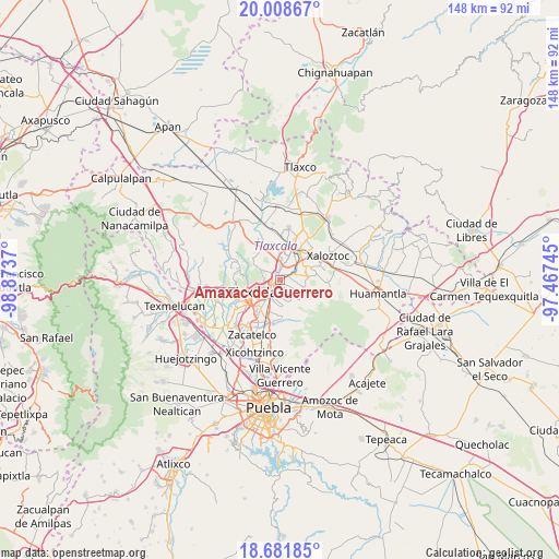
Amaxac de Guerrero GPS coordinates[2]
19° 20' 47.796" North, 98° 10' 14.052" West
| Map corner | latitude | longitude |
|---|---|---|
| Upper-left | 20.00867°, | -98.8737° |
| Center: | 19.34661°, | -98.17057° |
| Lower-right: | 18.68185°, | -97.46745° |
| Map W x H: | 147.5×147.5 km | = 91.7×91.7mi |
| max Lat: | 32.7° ⇑57.7% North |
| Amaxac de Guerrero: | 19.34661° |
| min Lat: | ⇓42.3% South 14.53588° |
| min Long | Amaxac de Guerr | max Long |
| -117.105° | -98.17057° | -86.73105° |
| W 61.6%⇐ | ⇒38.4% E |
Elevation
Elevation of Amaxac de Guerrero is 2303 m = 7556 ft, and this is 1049.3 m = 3443 ft above average elevation for this country.
| Max E: |
3497 m = 11473 ft | 13.2% |
| Amaxac de Guerrero | 2303 m 7556 ft | |
| Avg. | 1253.7 m = 4113 ft | |
Min E: |
-1 m = -3 ft | 86.8% |
See also: Mexico elevation on elevation.city.
Geographical zone
Amaxac de Guerrero is located in North Torrid zone (between Equator and Tropic of Cancer). Distance of this Northern Tropic circle is 454.8 km =282.6 mi to North.| Distance of | km | miles | from Amaxac de Guerrero |
|---|---|---|---|
| North Pole | 7855.9 | 4881.4 | to North |
| Arctic Circle | 5250 | 3262.2 | to North |
| Tropic Cancer | 454.8 | 282.6 | to North |
| Equator | 2151.1 | 1336.6 | to South |


Nearby cities:
15 places around Amaxac de Guerrero: (largest is in red/bold)
• Apetatitlán Antonio Carbajal
1.5 km =0.9 mi,  217°
217°
• Belén Atzitzimititlán
2 km =1.2 mi,  271°
271°
• Contla
2 km =1.2 mi,  167°
167°
• Ixtlahuaca
4.5 km =2.8 mi,  137°
137°
• Jesús Huitznahuac
4.5 km =2.8 mi,  95°
95°
• San José Tepoxtla
4.2 km =2.6 mi,  20°
20°
• San Lucas Tlacochcalco
2.6 km =1.6 mi, 99°
• San Matías Tepetomatitlán
2.7 km =1.7 mi,  287°
287°
• San Miguel Contla
4.3 km =2.7 mi,  68°
68°
• Santa Cruz Tlaxcala
2.3 km =1.4 mi, 66°
• Santa María Atlihuetzian
3.5 km =2.2 mi,  347°
347°
• Santa María Ixtulco
4.6 km =2.9 mi,  239°
239°
• Tecolotla
1.9 km =1.2 mi, 241°
• Tlatempan
3.8 km =2.4 mi, 244°
• Tlaxcala
4.3 km =2.7 mi,  225°
225°
Sources, notices
• [Note1] Compared only with cities in Mexico existing in our database
• [Src1] Map data: © OpenStreetMap contributors (CC-BY-SA)
• [Src2] Other city data from geonames.org with taken over terms of usage.
• [Src3] Geographical zone / Annual Mean Temperature by Robert A. Rohde @ Wikipedia
