El Cerro de las Huertas geodata
El Cerro de las Huertas (Oaxaca) is a populated place; located in Mexico in America/Mexico_City (GMT-6) time zone. With population of 633 people, there are 13682 cities with bigger population in this country. Compared to other cities in Mexico, 93.9% of cities are located further ↑North; 78.4% of cities are located further ←West and 51.6% of cities have lower elevation than El Cerro de las Huertas. Note1
Current local time in El Cerro de las Huertas:
11:20 AM, MondayDifference from your time zone: hours


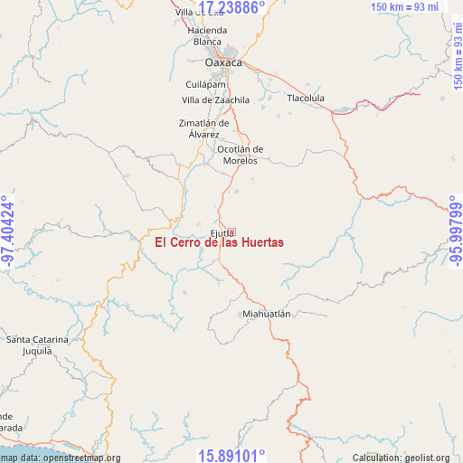
El Cerro de las Huertas GPS coordinates[2]
16° 33' 57.996" North, 96° 42' 3.996" West
| Map corner | latitude | longitude |
|---|---|---|
| Upper-left | 17.23886°, | -97.40424° |
| Center: | 16.56611°, | -96.70111° |
| Lower-right: | 15.89101°, | -95.99799° |
| Map W x H: | 149.9×149.9 km | = 93.1×93.1mi |
| max Lat: | 32.7° ⇑93.9% North |
| El Cerro de las Huertas: | 16.56611° |
| min Lat: | ⇓6.1% South 14.53588° |
| min Long | El Cerro de las | max Long |
| -117.105° | -96.70111° | -86.73105° |
| W 78.4%⇐ | ⇒21.6% E |
Elevation
Elevation of El Cerro de las Huertas is 1511 m = 4957 ft, and this is 257.3 m = 844 ft above average elevation for this country.
| Max E: |
3497 m = 11473 ft | 48.4% |
| El Cerro de las Huertas | 1511 m 4957 ft | |
| Avg. | 1253.7 m = 4113 ft | |
Min E: |
-1 m = -3 ft | 51.6% |
See also: Mexico elevation on elevation.city.
Geographical zone
El Cerro de las Huertas is located in North Torrid zone (between Equator and Tropic of Cancer). Distance of this Northern Tropic circle is 763.9 km =474.7 mi to North.| Distance of | km | miles | from El Cerro de las Huertas |
|---|---|---|---|
| North Pole | 8165.1 | 5073.6 | to North |
| Arctic Circle | 5559.2 | 3454.3 | to North |
| Tropic Cancer | 763.9 | 474.7 | to North |
| Equator | 1842 | 1144.6 | to South |


Nearby cities:
15 places around El Cerro de las Huertas: (largest is in red/bold)
• Agua del Espino
11.1 km =6.9 mi,  284°
284°
• Agua del Sol
11 km =6.8 mi,  197°
197°
• Barranca Larga
8.7 km =5.4 mi, 202°
• Coatecas Altas
4.6 km =2.9 mi,  130°
130°
• Ejutla de Crespo
3.2 km =2 mi,  270°
270°
• El Vergel
9.9 km =6.2 mi,  327°
327°
• Guixé
10.7 km =6.6 mi,  180°
180°
• Hacienda Vieja
6.8 km =4.2 mi,  244°
244°
• Los Ocotes
5.8 km =3.6 mi,  339°
339°
• San Agustín Amatengo
11.2 km =7 mi, 236°
• San Martín de los Canseco
10.4 km =6.5 mi, 344°
• San Miguel Ejutla
4.3 km =2.7 mi,  291°
291°
• Santa Martha Chichihualtepec
12.1 km =7.5 mi,  319°
319°
• Santa María Velato
9.1 km =5.7 mi,  139°
139°
• Taniche
5.8 km =3.6 mi, 272°
Sources, notices
• [Note1] Compared only with cities in Mexico existing in our database
• [Src1] Map data: © OpenStreetMap contributors (CC-BY-SA)
• [Src2] Other city data from geonames.org with taken over terms of usage.
• [Src3] Geographical zone / Annual Mean Temperature by Robert A. Rohde @ Wikipedia
