Coatecas Altas geodata
Coatecas Altas (Oaxaca) is a seat of a second-order administrative division; located in Mexico in America/Mexico_City (GMT-6) time zone. With population of 2,851 people, there are 3115 cities with bigger population in this country. Compared to other cities in Mexico, 94.1% of cities are located further ↑North; 78.7% of cities are located further ←West and 53.8% of cities have lower elevation than Coatecas Altas. Note1


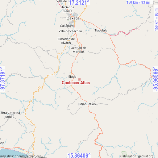
Coatecas Altas GPS coordinates[2]
16° 32' 21.336" North, 96° 40' 7.608" West
| Map corner | latitude | longitude |
|---|---|---|
| Upper-left | 17.2121°, | -97.37191° |
| Center: | 16.53926°, | -96.66878° |
| Lower-right: | 15.86406°, | -95.96566° |
| Map W x H: | 149.9×149.9 km | = 93.1×93.1mi |
| max Lat: | 32.7° ⇑94.1% North |
| Coatecas Altas: | 16.53926° |
| min Lat: | ⇓5.9% South 14.53588° |
| min Long | Coatecas Altas | max Long |
| -117.105° | -96.66878° | -86.73105° |
| W 78.7%⇐ | ⇒21.3% E |
Elevation
Elevation of Coatecas Altas is 1557 m = 5108 ft, and this is 303.3 m = 995 ft above average elevation for this country.
| Max E: |
3497 m = 11473 ft | 46.2% |
| Coatecas Altas | 1557 m 5108 ft | |
| Avg. | 1253.7 m = 4113 ft | |
Min E: |
-1 m = -3 ft | 53.8% |
See also: Mexico elevation on elevation.city.
Geographical zone
Coatecas Altas is located in North Torrid zone (between Equator and Tropic of Cancer). Distance of this Northern Tropic circle is 766.9 km =476.5 mi to North.| Distance of | km | miles | from Coatecas Altas |
|---|---|---|---|
| North Pole | 8168.1 | 5075.4 | to North |
| Arctic Circle | 5562.2 | 3456.2 | to North |
| Tropic Cancer | 766.9 | 476.5 | to North |
| Equator | 1839 | 1142.7 | to South |


Nearby cities:
15 places around Coatecas Altas: (largest is in red/bold)
• Agua del Sol
10.1 km =6.3 mi,  221°
221°
• Barranca Larga
8.5 km =5.3 mi,  233°
233°
• Ejutla de Crespo
7.3 km =4.5 mi,  294°
294°
• El Cerro de las Huertas
4.6 km =2.9 mi,  310°
310°
• El Zompantle
10.7 km =6.6 mi,  180°
180°
• Guixé
8.5 km =5.3 mi,  205°
205°
• Hacienda Vieja
9.6 km =6 mi,  270°
270°
• La Escalera
10.3 km =6.4 mi,  139°
139°
• Los Ocotes
10 km =6.2 mi,  327°
327°
• San Agustín Amatengo
13.2 km =8.2 mi,  256°
256°
• San Esteban Amatlán
13.3 km =8.3 mi,  107°
107°
• San Juán Lachigalla
13.8 km =8.6 mi,  66°
66°
• San Miguel Ejutla
8.8 km =5.5 mi,  301°
301°
• Santa María Velato
4.6 km =2.9 mi,  147°
147°
• Taniche
9.8 km =6.1 mi, 289°
Sources, notices
• [Note1] Compared only with cities in Mexico existing in our database
• [Src1] Map data: © OpenStreetMap contributors (CC-BY-SA)
• [Src2] Other city data from geonames.org with taken over terms of usage.
• [Src3] Geographical zone / Annual Mean Temperature by Robert A. Rohde @ Wikipedia
