Los Ocotes geodata
Los Ocotes (Oaxaca) is a populated place; located in Mexico in America/Mexico_City (GMT-6) time zone. With population of 581 people, there are 14753 cities with bigger population in this country. Compared to other cities in Mexico, 93.5% of cities are located further ↑North; 78.2% of cities are located further ←West and 52.5% of cities have lower elevation than Los Ocotes. Note1


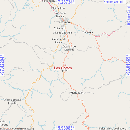
Los Ocotes GPS coordinates[2]
16° 36' 53.172" North, 96° 43' 11.316" West
| Map corner | latitude | longitude |
|---|---|---|
| Upper-left | 17.28734°, | -97.42294° |
| Center: | 16.61477°, | -96.71981° |
| Lower-right: | 15.93983°, | -96.01669° |
| Map W x H: | 149.8×149.8 km | = 93.1×93.1mi |
| max Lat: | 32.7° ⇑93.5% North |
| Los Ocotes: | 16.61477° |
| min Lat: | ⇓6.5% South 14.53588° |
| min Long | Los Ocotes | max Long |
| -117.105° | -96.71981° | -86.73105° |
| W 78.2%⇐ | ⇒21.8% E |
Elevation
Elevation of Los Ocotes is 1533 m = 5030 ft, and this is 279.3 m = 916 ft above average elevation for this country.
| Max E: |
3497 m = 11473 ft | 47.5% |
| Los Ocotes | 1533 m 5030 ft | |
| Avg. | 1253.7 m = 4113 ft | |
Min E: |
-1 m = -3 ft | 52.5% |
See also: Mexico elevation on elevation.city.
Geographical zone
Los Ocotes is located in North Torrid zone (between Equator and Tropic of Cancer). Distance of this Northern Tropic circle is 758.5 km =471.3 mi to North.| Distance of | km | miles | from Los Ocotes |
|---|---|---|---|
| North Pole | 8159.7 | 5070.2 | to North |
| Arctic Circle | 5553.8 | 3451 | to North |
| Tropic Cancer | 758.5 | 471.3 | to North |
| Equator | 1847.4 | 1147.9 | to South |


Nearby cities:
15 places around Los Ocotes: (largest is in red/bold)
• Agua del Espino
9.2 km =5.7 mi,  253°
253°
• Coatecas Altas
10 km =6.2 mi,  147°
147°
• Ejutla de Crespo
5.5 km =3.4 mi,  192°
192°
• El Cerro de las Huertas
5.8 km =3.6 mi,  159°
159°
• El Vergel
4.4 km =2.7 mi,  310°
310°
• Hacienda Vieja
9.3 km =5.8 mi,  206°
206°
• La Pe
8.5 km =5.3 mi,  281°
281°
• Magdalena Ocotlán
10.5 km =6.5 mi,  5°
5°
• Maguey Largo
10.2 km =6.3 mi,  41°
41°
• Monte del Toro
7.3 km =4.5 mi,  343°
343°
• San José del Progreso
8.8 km =5.5 mi,  25°
25°
• San Martín de los Canseco
4.7 km =2.9 mi,  349°
349°
• San Miguel Ejutla
4.3 km =2.7 mi, 208°
• Santa Martha Chichihualtepec
7 km =4.3 mi,  303°
303°
• Taniche
6.4 km =4 mi,  216°
216°
Sources, notices
• [Note1] Compared only with cities in Mexico existing in our database
• [Src1] Map data: © OpenStreetMap contributors (CC-BY-SA)
• [Src2] Other city data from geonames.org with taken over terms of usage.
• [Src3] Geographical zone / Annual Mean Temperature by Robert A. Rohde @ Wikipedia
