Chalchitepec geodata
Chalchitepec (Veracruz) is a populated place; located in Mexico in America/Mexico_City (GMT-6) time zone. With population of 632 people, there are 13699 cities with bigger population in this country. Compared to other cities in Mexico, 62% of cities are located further ↑North; 74.4% of cities are located further ←West and 64.3% of cities have lower elevation than Chalchitepec. Note1


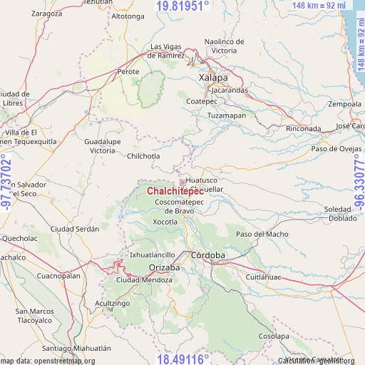
Chalchitepec GPS coordinates[2]
19° 9' 24.012" North, 97° 2' 2.004" West
| Map corner | latitude | longitude |
|---|---|---|
| Upper-left | 19.81951°, | -97.73702° |
| Center: | 19.15667°, | -97.03389° |
| Lower-right: | 18.49116°, | -96.33077° |
| Map W x H: | 147.7×147.7 km | = 91.8×91.8mi |
| max Lat: | 32.7° ⇑62% North |
| Chalchitepec: | 19.15667° |
| min Lat: | ⇓38% South 14.53588° |
| min Long | Chalchitepec | max Long |
| -117.105° | -97.03389° | -86.73105° |
| W 74.4%⇐ | ⇒25.6% E |
Elevation
Elevation of Chalchitepec is 1809 m = 5935 ft, and this is 555.3 m = 1822 ft above average elevation for this country.
| Max E: |
3497 m = 11473 ft | 35.7% |
| Chalchitepec | 1809 m 5935 ft | |
| Avg. | 1253.7 m = 4113 ft | |
Min E: |
-1 m = -3 ft | 64.3% |
See also: Mexico elevation on elevation.city.
Geographical zone
Chalchitepec is located in North Torrid zone (between Equator and Tropic of Cancer). Distance of this Northern Tropic circle is 475.9 km =295.7 mi to North.| Distance of | km | miles | from Chalchitepec |
|---|---|---|---|
| North Pole | 7877 | 4894.5 | to North |
| Arctic Circle | 5271.2 | 3275.4 | to North |
| Tropic Cancer | 475.9 | 295.7 | to North |
| Equator | 2130 | 1323.5 | to South |


Nearby cities:
15 places around Chalchitepec: (largest is in red/bold)
• Adolfo Ruiz Cortines (La Pastoría)
3.8 km =2.4 mi,  109°
109°
• Atlaxco
6.8 km =4.2 mi,  300°
300°
• Calcahualco
6.6 km =4.1 mi,  234°
234°
• Chichiquila
6 km =3.7 mi,  324°
324°
• Colonia Francisco I. Madero
5.1 km =3.2 mi,  131°
131°
• Colonia Pastoría Cuatro
5.3 km =3.3 mi,  97°
97°
• Dos Ríos
5.3 km =3.3 mi, 304°
• El Palmar
2.8 km =1.7 mi, 226°
• El Progreso
1.8 km =1.1 mi, 298°
• Elotepec
3.5 km =2.2 mi,  353°
353°
• Nenehuaca
1.7 km =1.1 mi,  211°
211°
• Rancho Nuevo
3.3 km =2.1 mi, 320°
• Tepampa
2 km =1.2 mi,  144°
144°
• Tizapa
4.6 km =2.9 mi,  292°
292°
• Tres Aguas
4.2 km =2.6 mi,  200°
200°
Sources, notices
• [Note1] Compared only with cities in Mexico existing in our database
• [Src1] Map data: © OpenStreetMap contributors (CC-BY-SA)
• [Src2] Other city data from geonames.org with taken over terms of usage.
• [Src3] Geographical zone / Annual Mean Temperature by Robert A. Rohde @ Wikipedia
