Coyol (Vega Larga) geodata
Coyol (Vega Larga) (San Luis Potosí) is a populated place; located in Mexico in America/Mexico_City (GMT-6) time zone. With population of 567 people, there are 15067 cities with bigger population in this country. Compared to other cities in Mexico, 79.7% of cities are located further ↓South; 52.7% of cities are located further ←West and 68.8% of cities have higher elevation than Coyol (Vega Larga). Note1


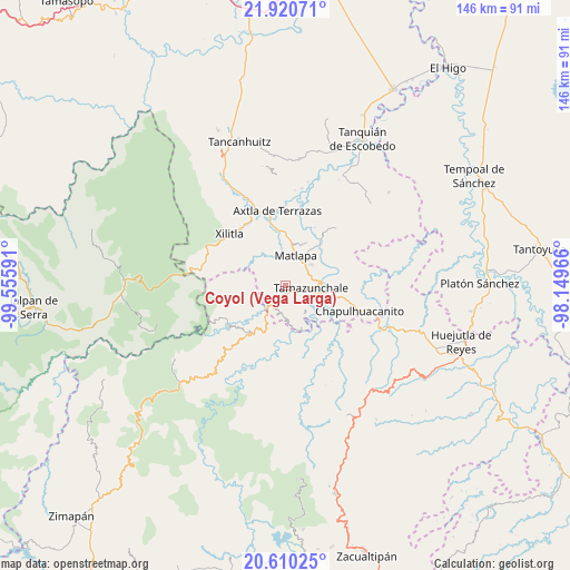
Coyol (Vega Larga) GPS coordinates[2]
21° 16' 0.984" North, 98° 51' 10.008" West
| Map corner | latitude | longitude |
|---|---|---|
| Upper-left | 21.92071°, | -99.55591° |
| Center: | 21.26694°, | -98.85278° |
| Lower-right: | 20.61025°, | -98.14966° |
| Map W x H: | 145.7×145.7 km | = 90.5×90.5mi |
| max Lat: | 32.7° ⇑20.3% North |
| Coyol (Vega Larga): | 21.26694° |
| min Lat: | ⇓79.7% South 14.53588° |
| min Long | Coyol (Vega Lar | max Long |
| -117.105° | -98.85278° | -86.73105° |
| W 52.7%⇐ | ⇒47.3% E |
Elevation
Elevation of Coyol (Vega Larga) is 479 m = 1572 ft, and this is 774.7 m = 2542 ft below average elevation for this country.
| Max E: |
3497 m = 11473 ft | 68.8% |
| Avg. | 1253.7 m = 4113 ft | |
| Coyol (Vega Larga) | 479 m = 1572 ft | |
Min E: |
-1 m = -3 ft | 31.2% |
See also: Mexico elevation on elevation.city.
Geographical zone
Coyol (Vega Larga) is located in North Torrid zone (between Equator and Tropic of Cancer). Distance of this Northern Tropic circle is 241.3 km =149.9 mi to North.| Distance of | km | miles | from Coyol (Vega Larga) |
|---|---|---|---|
| North Pole | 7642.4 | 4748.8 | to North |
| Arctic Circle | 5036.5 | 3129.5 | to North |
| Tropic Cancer | 241.3 | 149.9 | to North |
| Equator | 2364.7 | 1469.4 | to South |


Nearby cities:
15 places around Coyol (Vega Larga): (largest is in red/bold)
• Ahuehueyo
4.8 km =3 mi,  64°
64°
• Amatitla Santiago
5.3 km =3.3 mi,  186°
186°
• Amatitla Tamán
4.6 km =2.9 mi, 187°
• Atlamaxátl
5.7 km =3.5 mi,  30°
30°
• Barrio de Guadalupe
5 km =3.1 mi,  219°
219°
• Huazalingo
2.6 km =1.6 mi,  165°
165°
• Papatlaco Santiago
4.7 km =2.9 mi, 166°
• San Francisco
4.2 km =2.6 mi,  289°
289°
• Tacial
4.6 km =2.9 mi,  104°
104°
• Tamacol
4.6 km =2.9 mi,  141°
141°
• Tamán
4.8 km =3 mi, 215°
• Tepetzintla
5.4 km =3.4 mi,  37°
37°
• Tlacuilola
3.6 km =2.2 mi,  205°
205°
• Vega Larga
1.8 km =1.1 mi,  130°
130°
• Xaltipa
2.2 km =1.4 mi,  197°
197°
Sources, notices
• [Note1] Compared only with cities in Mexico existing in our database
• [Src1] Map data: © OpenStreetMap contributors (CC-BY-SA)
• [Src2] Other city data from geonames.org with taken over terms of usage.
• [Src3] Geographical zone / Annual Mean Temperature by Robert A. Rohde @ Wikipedia
