Epapa geodata
Epapa (Veracruz) is a populated place; located in Mexico in America/Mexico_City (GMT-6) time zone. With population of 557 people, there are 15314 cities with bigger population in this country. Compared to other cities in Mexico, 55.2% of cities are located further ↓South; 71.7% of cities are located further ←West and 59.6% of cities have higher elevation than Epapa. Note1


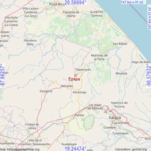
Epapa GPS coordinates[2]
19° 54' 25.992" North, 97° 16' 45.984" West
| Map corner | latitude | longitude |
|---|---|---|
| Upper-left | 20.56694°, | -97.98257° |
| Center: | 19.90722°, | -97.27944° |
| Lower-right: | 19.24474°, | -96.57632° |
| Map W x H: | 147×147 km | = 91.3×91.3mi |
| max Lat: | 32.7° ⇑44.8% North |
| Epapa: | 19.90722° |
| min Lat: | ⇓55.2% South 14.53588° |
| min Long | Epapa | max Long |
| -117.105° | -97.27944° | -86.73105° |
| W 71.7%⇐ | ⇒28.3% E |
Elevation
Elevation of Epapa is 1020 m = 3346 ft, and this is 233.7 m = 767 ft below average elevation for this country.
| Max E: |
3497 m = 11473 ft | 59.6% |
| Avg. | 1253.7 m = 4113 ft | |
| Epapa | 1020 m = 3346 ft | |
Min E: |
-1 m = -3 ft | 40.4% |
See also: Mexico elevation on elevation.city.
Geographical zone
Epapa is located in North Torrid zone (between Equator and Tropic of Cancer). Distance of this Northern Tropic circle is 392.4 km =243.8 mi to North.| Distance of | km | miles | from Epapa |
|---|---|---|---|
| North Pole | 7793.6 | 4842.7 | to North |
| Arctic Circle | 5187.7 | 3223.5 | to North |
| Tropic Cancer | 392.4 | 243.8 | to North |
| Equator | 2213.5 | 1375.4 | to South |


Nearby cities:
15 places around Epapa: (largest is in red/bold)
• Amatetel
6.2 km =3.9 mi,  334°
334°
• Congregación Hidalgo
6.7 km =4.2 mi,  25°
25°
• Conta
3.2 km =2 mi,  315°
315°
• Ejido Hueytamalco
5.1 km =3.2 mi,  223°
223°
• El Arco
5.1 km =3.2 mi,  55°
55°
• El Mohón
0.2 km =0.1 mi,  287°
287°
• Eytepéquez
5.9 km =3.7 mi,  52°
52°
• Hueytamalco
3.8 km =2.4 mi,  345°
345°
• Limontitán Grande
9.2 km =5.7 mi,  0°
0°
• Melchor Ocampo
8 km =5 mi,  200°
200°
• Napoala
6 km =3.7 mi,  92°
92°
• Nicolás Bravo
3.2 km =2 mi,  132°
132°
• San Isidro
8.5 km =5.3 mi,  41°
41°
• Santa Cruz
7.2 km =4.5 mi, 61°
• Vicente Guerrero
1.7 km =1.1 mi, 46°
Sources, notices
• [Note1] Compared only with cities in Mexico existing in our database
• [Src1] Map data: © OpenStreetMap contributors (CC-BY-SA)
• [Src2] Other city data from geonames.org with taken over terms of usage.
• [Src3] Geographical zone / Annual Mean Temperature by Robert A. Rohde @ Wikipedia
