Eytepéquez geodata
Eytepéquez (Veracruz) is a populated place; located in Mexico in America/Mexico_City (GMT-6) time zone. With population of 907 people, there are 9625 cities with bigger population in this country. Compared to other cities in Mexico, 55.8% of cities are located further ↓South; 72.1% of cities are located further ←West and 66.4% of cities have higher elevation than Eytepéquez. Note1


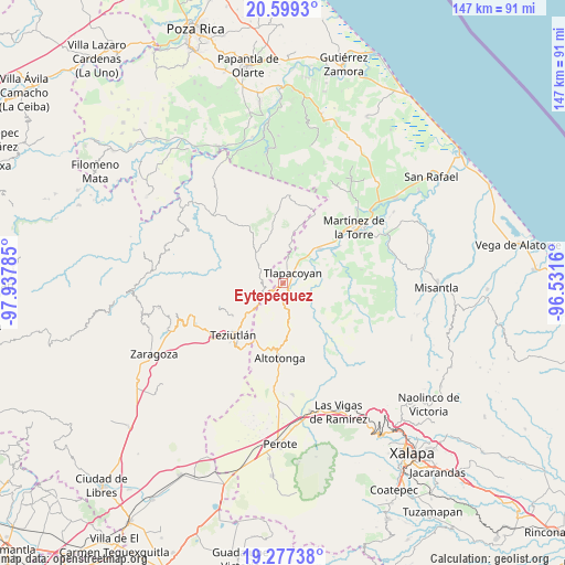
Eytepéquez GPS coordinates[2]
19° 56' 22.992" North, 97° 14' 4.992" West
| Map corner | latitude | longitude |
|---|---|---|
| Upper-left | 20.5993°, | -97.93785° |
| Center: | 19.93972°, | -97.23472° |
| Lower-right: | 19.27738°, | -96.5316° |
| Map W x H: | 147×147 km | = 91.3×91.3mi |
| max Lat: | 32.7° ⇑44.2% North |
| Eytepéquez: | 19.93972° |
| min Lat: | ⇓55.8% South 14.53588° |
| min Long | Eytepéquez | max Long |
| -117.105° | -97.23472° | -86.73105° |
| W 72.1%⇐ | ⇒27.9% E |
Elevation
Elevation of Eytepéquez is 619 m = 2031 ft, and this is 634.7 m = 2082 ft below average elevation for this country.
| Max E: |
3497 m = 11473 ft | 66.4% |
| Avg. | 1253.7 m = 4113 ft | |
| Eytepéquez | 619 m = 2031 ft | |
Min E: |
-1 m = -3 ft | 33.6% |
See also: Mexico elevation on elevation.city.
Geographical zone
Eytepéquez is located in North Torrid zone (between Equator and Tropic of Cancer). Distance of this Northern Tropic circle is 388.8 km =241.6 mi to North.| Distance of | km | miles | from Eytepéquez |
|---|---|---|---|
| North Pole | 7790 | 4840.5 | to North |
| Arctic Circle | 5184.1 | 3221.2 | to North |
| Tropic Cancer | 388.8 | 241.6 | to North |
| Equator | 2217.1 | 1377.6 | to South |


Nearby cities:
15 places around Eytepéquez: (largest is in red/bold)
• Congregación Hidalgo
3 km =1.9 mi,  323°
323°
• Conta
7 km =4.3 mi,  259°
259°
• Cuauzapotitán
6.9 km =4.3 mi,  128°
128°
• El Arco
0.9 km =0.6 mi,  216°
216°
• El Campamento
7 km =4.3 mi,  80°
80°
• El Mohón
6 km =3.7 mi,  234°
234°
• Epapa
5.9 km =3.7 mi, 232°
• Hueytamalco
5.6 km =3.5 mi,  270°
270°
• Napoala
4.1 km =2.5 mi,  161°
161°
• Nicolás Bravo
6.2 km =3.9 mi,  202°
202°
• Piedra Pinta
7 km =4.3 mi,  35°
35°
• San Isidro
2.9 km =1.8 mi,  18°
18°
• Santa Cruz
1.7 km =1.1 mi,  98°
98°
• Tlapacoyan
3.5 km =2.2 mi, 43°
• Vicente Guerrero
4.2 km =2.6 mi, 234°
Sources, notices
• [Note1] Compared only with cities in Mexico existing in our database
• [Src1] Map data: © OpenStreetMap contributors (CC-BY-SA)
• [Src2] Other city data from geonames.org with taken over terms of usage.
• [Src3] Geographical zone / Annual Mean Temperature by Robert A. Rohde @ Wikipedia
