Vicente Guerrero geodata
Vicente Guerrero (Veracruz) is a populated place; located in Mexico in America/Mexico_City (GMT-6) time zone. With population of 617 people, there are 13976 cities with bigger population in this country. Compared to other cities in Mexico, 55.4% of cities are located further ↓South; 71.8% of cities are located further ←West and 60.2% of cities have higher elevation than Vicente Guerrero. Note1


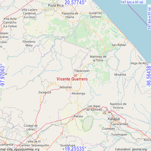
Vicente Guerrero GPS coordinates[2]
19° 55' 4.008" North, 97° 16' 3" West
| Map corner | latitude | longitude |
|---|---|---|
| Upper-left | 20.57745°, | -97.97063° |
| Center: | 19.91778°, | -97.2675° |
| Lower-right: | 19.25535°, | -96.56438° |
| Map W x H: | 147×147 km | = 91.3×91.3mi |
| max Lat: | 32.7° ⇑44.6% North |
| Vicente Guerrero: | 19.91778° |
| min Lat: | ⇓55.4% South 14.53588° |
| min Long | Vicente Guerrer | max Long |
| -117.105° | -97.2675° | -86.73105° |
| W 71.8%⇐ | ⇒28.2% E |
Elevation
Elevation of Vicente Guerrero is 988 m = 3241 ft, and this is 265.7 m = 872 ft below average elevation for this country.
| Max E: |
3497 m = 11473 ft | 60.2% |
| Avg. | 1253.7 m = 4113 ft | |
| Vicente Guerrero | 988 m = 3241 ft | |
Min E: |
-1 m = -3 ft | 39.8% |
See also: Mexico elevation on elevation.city.
Geographical zone
Vicente Guerrero is located in North Torrid zone (between Equator and Tropic of Cancer). Distance of this Northern Tropic circle is 391.3 km =243.1 mi to North.| Distance of | km | miles | from Vicente Guerrero |
|---|---|---|---|
| North Pole | 7792.4 | 4842 | to North |
| Arctic Circle | 5186.5 | 3222.7 | to North |
| Tropic Cancer | 391.3 | 243.1 | to North |
| Equator | 2214.6 | 1376.1 | to South |


Nearby cities:
15 places around Vicente Guerrero: (largest is in red/bold)
• Amatetel
5.9 km =3.7 mi,  318°
318°
• Congregación Hidalgo
5.1 km =3.2 mi,  18°
18°
• Conta
3.7 km =2.3 mi,  287°
287°
• Ejido Hueytamalco
6.8 km =4.2 mi,  224°
224°
• El Arco
3.4 km =2.1 mi,  59°
59°
• El Mohón
1.8 km =1.1 mi,  232°
232°
• Epapa
1.7 km =1.1 mi, 226°
• Eytepéquez
4.2 km =2.6 mi,  54°
54°
• Hueytamalco
3.3 km =2.1 mi, 318°
• Limontitán Grande
8.1 km =5 mi,  351°
351°
• Napoala
4.9 km =3 mi,  106°
106°
• Nicolás Bravo
3.5 km =2.2 mi,  161°
161°
• San Isidro
6.8 km =4.2 mi,  39°
39°
• Santa Cruz
5.5 km =3.4 mi,  66°
66°
• Tlapacoyan
7.7 km =4.8 mi, 49°
Sources, notices
• [Note1] Compared only with cities in Mexico existing in our database
• [Src1] Map data: © OpenStreetMap contributors (CC-BY-SA)
• [Src2] Other city data from geonames.org with taken over terms of usage.
• [Src3] Geographical zone / Annual Mean Temperature by Robert A. Rohde @ Wikipedia
