Ignacio Allende geodata
Ignacio Allende (Chiapas) is a populated place; located in Mexico in America/Mexico_City (GMT-6) time zone. With population of 552 people, there are 15449 cities with bigger population in this country. Compared to other cities in Mexico, 95.6% of cities are located further ↑North; 95.6% of cities are located further ←West and 51.3% of cities have lower elevation than Ignacio Allende. Note1


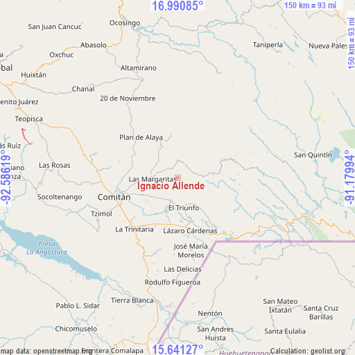
Ignacio Allende GPS coordinates[2]
16° 19' 1.992" North, 91° 52' 59.016" West
| Map corner | latitude | longitude |
|---|---|---|
| Upper-left | 16.99085°, | -92.58619° |
| Center: | 16.31722°, | -91.88306° |
| Lower-right: | 15.64127°, | -91.17994° |
| Map W x H: | 150.1×150.1 km | = 93.3×93.3mi |
| max Lat: | 32.7° ⇑95.6% North |
| Ignacio Allende: | 16.31722° |
| min Lat: | ⇓4.4% South 14.53588° |
| min Long | Ignacio Allende | max Long |
| -117.105° | -91.88306° | -86.73105° |
| W 95.6%⇐ | ⇒4.4% E |
Elevation
Elevation of Ignacio Allende is 1499 m = 4918 ft, and this is 245.3 m = 805 ft above average elevation for this country.
| Max E: |
3497 m = 11473 ft | 48.7% |
| Ignacio Allende | 1499 m 4918 ft | |
| Avg. | 1253.7 m = 4113 ft | |
Min E: |
-1 m = -3 ft | 51.3% |
See also: Mexico elevation on elevation.city.
Geographical zone
Ignacio Allende is located in North Torrid zone (between Equator and Tropic of Cancer). Distance of this Northern Tropic circle is 791.6 km =491.9 mi to North.| Distance of | km | miles | from Ignacio Allende |
|---|---|---|---|
| North Pole | 8192.8 | 5090.8 | to North |
| Arctic Circle | 5586.9 | 3471.5 | to North |
| Tropic Cancer | 791.6 | 491.9 | to North |
| Equator | 1814.3 | 1127.4 | to South |


Nearby cities:
15 places around Ignacio Allende: (largest is in red/bold)
• Artículo 27
6 km =3.7 mi,  154°
154°
• Belisario Domínguez
9.9 km =6.2 mi,  2°
2°
• Buenavista Pachán
8.9 km =5.5 mi,  92°
92°
• El Campamento
8.9 km =5.5 mi,  256°
256°
• El Encanto
7.5 km =4.7 mi,  289°
289°
• El Progreso
4.9 km =3 mi,  250°
250°
• Espíritu Santo
9.4 km =5.8 mi,  279°
279°
• Francisco I. Madero
3.7 km =2.3 mi,  226°
226°
• Francisco Sarabia
11.5 km =7.1 mi, 227°
• Gabino Vázquez San Sebastián
6.9 km =4.3 mi,  302°
302°
• Ignacio Zaragoza
5.5 km =3.4 mi,  316°
316°
• La Patria
10.2 km =6.3 mi,  197°
197°
• Las Margaritas
10.5 km =6.5 mi,  267°
267°
• Saltillo
11 km =6.8 mi, 320°
• San Antonio Chiquinivaltic
9.6 km =6 mi,  206°
206°
Sources, notices
• [Note1] Compared only with cities in Mexico existing in our database
• [Src1] Map data: © OpenStreetMap contributors (CC-BY-SA)
• [Src2] Other city data from geonames.org with taken over terms of usage.
• [Src3] Geographical zone / Annual Mean Temperature by Robert A. Rohde @ Wikipedia
