El Progreso geodata
El Progreso (Chiapas) is a populated place; located in Mexico in America/Mexico_City (GMT-6) time zone. With population of 1,007 people, there are 8660 cities with bigger population in this country. Compared to other cities in Mexico, 95.6% of cities are located further ↑North; 95.6% of cities are located further ←West and 51.1% of cities have lower elevation than El Progreso. Note1


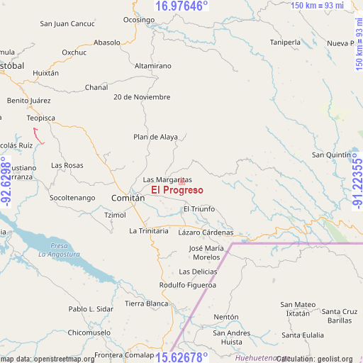
El Progreso GPS coordinates[2]
16° 18' 10.008" North, 91° 55' 36.012" West
| Map corner | latitude | longitude |
|---|---|---|
| Upper-left | 16.97646°, | -92.6298° |
| Center: | 16.30278°, | -91.92667° |
| Lower-right: | 15.62678°, | -91.22355° |
| Map W x H: | 150.1×150.1 km | = 93.3×93.3mi |
| max Lat: | 32.7° ⇑95.6% North |
| El Progreso: | 16.30278° |
| min Lat: | ⇓4.4% South 14.53588° |
| min Long | El Progreso | max Long |
| -117.105° | -91.92667° | -86.73105° |
| W 95.6%⇐ | ⇒4.4% E |
Elevation
Elevation of El Progreso is 1491 m = 4892 ft, and this is 237.3 m = 779 ft above average elevation for this country.
| Max E: |
3497 m = 11473 ft | 48.9% |
| El Progreso | 1491 m 4892 ft | |
| Avg. | 1253.7 m = 4113 ft | |
Min E: |
-1 m = -3 ft | 51.1% |
See also: Mexico elevation on elevation.city.
Geographical zone
El Progreso is located in North Torrid zone (between Equator and Tropic of Cancer). Distance of this Northern Tropic circle is 793.2 km =492.9 mi to North.| Distance of | km | miles | from El Progreso |
|---|---|---|---|
| North Pole | 8194.4 | 5091.8 | to North |
| Arctic Circle | 5588.5 | 3472.5 | to North |
| Tropic Cancer | 793.2 | 492.9 | to North |
| Equator | 1812.7 | 1126.4 | to South |


Nearby cities:
15 places around El Progreso: (largest is in red/bold)
• Artículo 27
8.2 km =5.1 mi,  117°
117°
• Buenavista
9.3 km =5.8 mi,  224°
224°
• El Campamento
4 km =2.5 mi,  263°
263°
• El Encanto
4.8 km =3 mi,  329°
329°
• Espíritu Santo
5.6 km =3.5 mi,  304°
304°
• Francisco I. Madero
2.2 km =1.4 mi, 115°
• Francisco Sarabia
7.3 km =4.5 mi,  212°
212°
• Gabino Vázquez San Sebastián
5.4 km =3.4 mi,  348°
348°
• Ignacio Allende
4.9 km =3 mi,  70°
70°
• Ignacio Zaragoza
5.7 km =3.5 mi,  8°
8°
• La Patria
8.3 km =5.2 mi,  168°
168°
• Las Margaritas
5.9 km =3.7 mi,  280°
280°
• San Antonio Chiquinivaltic
7 km =4.3 mi,  177°
177°
• San José las Palmas
10 km =6.2 mi,  290°
290°
• Yalcoc
7.9 km =4.9 mi, 301°
Sources, notices
• [Note1] Compared only with cities in Mexico existing in our database
• [Src1] Map data: © OpenStreetMap contributors (CC-BY-SA)
• [Src2] Other city data from geonames.org with taken over terms of usage.
• [Src3] Geographical zone / Annual Mean Temperature by Robert A. Rohde @ Wikipedia
