El Campamento geodata
El Campamento (Chiapas) is a populated place; located in Mexico in America/Mexico_City (GMT-6) time zone. With population of 547 people, there are 15556 cities with bigger population in this country. Compared to other cities in Mexico, 95.7% of cities are located further ↑North; 95.4% of cities are located further ←West and 51.6% of cities have lower elevation than El Campamento. Note1


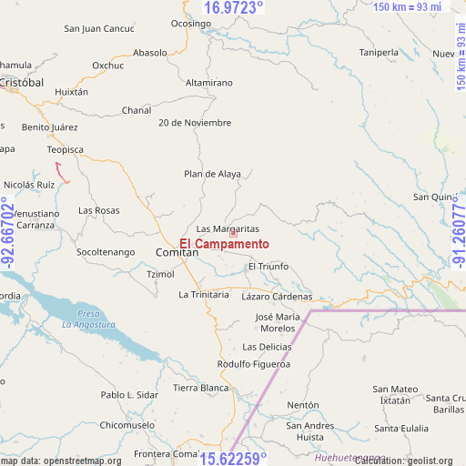
El Campamento GPS coordinates[2]
16° 17' 54.996" North, 91° 57' 50.004" West
| Map corner | latitude | longitude |
|---|---|---|
| Upper-left | 16.9723°, | -92.66702° |
| Center: | 16.29861°, | -91.96389° |
| Lower-right: | 15.62259°, | -91.26077° |
| Map W x H: | 150.1×150.1 km | = 93.3×93.3mi |
| max Lat: | 32.7° ⇑95.7% North |
| El Campamento: | 16.29861° |
| min Lat: | ⇓4.3% South 14.53588° |
| min Long | El Campamento | max Long |
| -117.105° | -91.96389° | -86.73105° |
| W 95.4%⇐ | ⇒4.6% E |
Elevation
Elevation of El Campamento is 1509 m = 4951 ft, and this is 255.3 m = 838 ft above average elevation for this country.
| Max E: |
3497 m = 11473 ft | 48.4% |
| El Campamento | 1509 m 4951 ft | |
| Avg. | 1253.7 m = 4113 ft | |
Min E: |
-1 m = -3 ft | 51.6% |
See also: Mexico elevation on elevation.city.
Geographical zone
El Campamento is located in North Torrid zone (between Equator and Tropic of Cancer). Distance of this Northern Tropic circle is 793.7 km =493.2 mi to North.| Distance of | km | miles | from El Campamento |
|---|---|---|---|
| North Pole | 8194.8 | 5092 | to North |
| Arctic Circle | 5588.9 | 3472.8 | to North |
| Tropic Cancer | 793.7 | 493.2 | to North |
| Equator | 1812.2 | 1126 | to South |


Nearby cities:
15 places around El Campamento: (largest is in red/bold)
• Buenavista
6.7 km =4.2 mi,  202°
202°
• El Encanto
4.9 km =3 mi,  18°
18°
• El Progreso
4 km =2.5 mi,  83°
83°
• Espíritu Santo
3.7 km =2.3 mi,  350°
350°
• Francisco I. Madero
6 km =3.7 mi,  94°
94°
• Francisco Sarabia
5.7 km =3.5 mi,  178°
178°
• Gabino Vázquez San Sebastián
6.4 km =4 mi,  26°
26°
• Ignacio Allende
8.9 km =5.5 mi, 76°
• Ignacio Zaragoza
7.7 km =4.8 mi,  38°
38°
• La Independencia
8.2 km =5.1 mi,  231°
231°
• Las Margaritas
2.4 km =1.5 mi,  310°
310°
• Primero de Mayo
7.3 km =4.5 mi,  256°
256°
• San Antonio Chiquinivaltic
7.8 km =4.8 mi,  146°
146°
• San José las Palmas
6.7 km =4.2 mi, 306°
• Yalcoc
5.3 km =3.3 mi,  329°
329°
Sources, notices
• [Note1] Compared only with cities in Mexico existing in our database
• [Src1] Map data: © OpenStreetMap contributors (CC-BY-SA)
• [Src2] Other city data from geonames.org with taken over terms of usage.
• [Src3] Geographical zone / Annual Mean Temperature by Robert A. Rohde @ Wikipedia
