Nuevo Jerusalén geodata
Nuevo Jerusalén (Chiapas) is a populated place; located in Mexico in America/Mexico_City (GMT-6) time zone. With population of 540 people, there are 15727 cities with bigger population in this country. Compared to other cities in Mexico, 90.3% of cities are located further ↑North; 95.2% of cities are located further ←West and 62.2% of cities have higher elevation than Nuevo Jerusalén. Note1


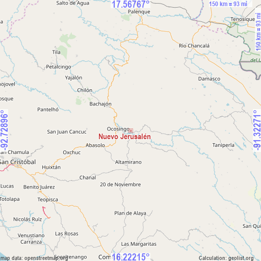
Nuevo Jerusalén GPS coordinates[2]
16° 53' 45.996" North, 92° 1' 32.988" West
| Map corner | latitude | longitude |
|---|---|---|
| Upper-left | 17.56767°, | -92.72896° |
| Center: | 16.89611°, | -92.02583° |
| Lower-right: | 16.22215°, | -91.32271° |
| Map W x H: | 149.6×149.6 km | = 93×93mi |
| max Lat: | 32.7° ⇑90.3% North |
| Nuevo Jerusalén: | 16.89611° |
| min Lat: | ⇓9.7% South 14.53588° |
| min Long | Nuevo Jerusalé | max Long |
| -117.105° | -92.02583° | -86.73105° |
| W 95.2%⇐ | ⇒4.8% E |
Elevation
Elevation of Nuevo Jerusalén is 873 m = 2864 ft, and this is 380.7 m = 1249 ft below average elevation for this country.
| Max E: |
3497 m = 11473 ft | 62.2% |
| Avg. | 1253.7 m = 4113 ft | |
| Nuevo Jerusalén | 873 m = 2864 ft | |
Min E: |
-1 m = -3 ft | 37.8% |
See also: Mexico elevation on elevation.city.
Geographical zone
Nuevo Jerusalén is located in North Torrid zone (between Equator and Tropic of Cancer). Distance of this Northern Tropic circle is 727.2 km =451.9 mi to North.| Distance of | km | miles | from Nuevo Jerusalén |
|---|---|---|---|
| North Pole | 8128.4 | 5050.8 | to North |
| Arctic Circle | 5522.5 | 3431.5 | to North |
| Tropic Cancer | 727.2 | 451.9 | to North |
| Equator | 1878.7 | 1167.4 | to South |


Nearby cities:
15 places around Nuevo Jerusalén: (largest is in red/bold)
• Altamirano
13.3 km =8.3 mi,  263°
263°
• Chiquinival
12.7 km =7.9 mi,  33°
33°
• El Carmen
13.1 km =8.1 mi,  354°
354°
• Joaquín Miguel Gutiérrez
8.7 km =5.4 mi,  185°
185°
• La Reforma
15 km =9.3 mi,  62°
62°
• La Virginia
15.9 km =9.9 mi, 262°
• Los Pinos
9.2 km =5.7 mi,  287°
287°
• Nazaret
15.1 km =9.4 mi,  52°
52°
• Nuevo Paraíso
4.9 km =3 mi, 260°
• Ocosingo
7.3 km =4.5 mi,  278°
278°
• Patria Nueva (San José el Contento)
10 km =6.2 mi, 290°
• San Antonio las Delicias (Pamala)
16.1 km =10 mi,  94°
94°
• Santiago Pojcol
11.6 km =7.2 mi,  24°
24°
• Sibacá
12.8 km =8 mi, 287°
• Tzobojitle Jotoaquil
13.1 km =8.1 mi,  341°
341°
Sources, notices
• [Note1] Compared only with cities in Mexico existing in our database
• [Src1] Map data: © OpenStreetMap contributors (CC-BY-SA)
• [Src2] Other city data from geonames.org with taken over terms of usage.
• [Src3] Geographical zone / Annual Mean Temperature by Robert A. Rohde @ Wikipedia
