La Reforma geodata
La Reforma (Chiapas) is a populated place; located in Mexico in America/Mexico_City (GMT-6) time zone. With population of 925 people, there are 9432 cities with bigger population in this country. Compared to other cities in Mexico, 89.5% of cities are located further ↑North; 95.6% of cities are located further ←West and 63.5% of cities have higher elevation than La Reforma. Note1


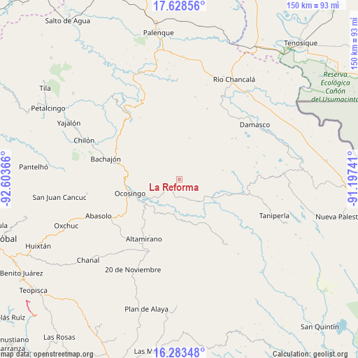
La Reforma GPS coordinates[2]
16° 57' 25.992" North, 91° 54' 1.908" West
| Map corner | latitude | longitude |
|---|---|---|
| Upper-left | 17.62856°, | -92.60366° |
| Center: | 16.95722°, | -91.90053° |
| Lower-right: | 16.28348°, | -91.19741° |
| Map W x H: | 149.6×149.6 km | = 93×93mi |
| max Lat: | 32.7° ⇑89.5% North |
| La Reforma: | 16.95722° |
| min Lat: | ⇓10.5% South 14.53588° |
| min Long | La Reforma | max Long |
| -117.105° | -91.90053° | -86.73105° |
| W 95.6%⇐ | ⇒4.4% E |
Elevation
Elevation of La Reforma is 783 m = 2569 ft, and this is 470.7 m = 1544 ft below average elevation for this country.
| Max E: |
3497 m = 11473 ft | 63.5% |
| Avg. | 1253.7 m = 4113 ft | |
| La Reforma | 783 m = 2569 ft | |
Min E: |
-1 m = -3 ft | 36.5% |
See also: Mexico elevation on elevation.city.
Geographical zone
La Reforma is located in North Torrid zone (between Equator and Tropic of Cancer). Distance of this Northern Tropic circle is 720.5 km =447.7 mi to North.| Distance of | km | miles | from La Reforma |
|---|---|---|---|
| North Pole | 8121.6 | 5046.5 | to North |
| Arctic Circle | 5515.7 | 3427.3 | to North |
| Tropic Cancer | 720.5 | 447.7 | to North |
| Equator | 1885.5 | 1171.6 | to South |


Nearby cities:
15 places around La Reforma: (largest is in red/bold)
• Chiquinival
7.4 km =4.6 mi,  300°
300°
• Cinco de Febrero
18.8 km =11.7 mi,  78°
78°
• El Carmen
15.9 km =9.9 mi,  293°
293°
• Jet-Já
12.6 km =7.8 mi,  346°
346°
• Jol Sacún
18 km =11.2 mi,  14°
14°
• Nazaret
2.7 km =1.7 mi,  330°
330°
• Nuevo Jerusalén
15 km =9.3 mi,  242°
242°
• Nuevo Paraíso
19.7 km =12.2 mi,  247°
247°
• Pamal Navil
17.5 km =10.9 mi,  36°
36°
• Sacún Cubwitz
19.6 km =12.2 mi, 347°
• San Antonio las Delicias (Pamala)
8.5 km =5.3 mi,  161°
161°
• San Miguel
18.6 km =11.6 mi, 163°
• San Salvador
3 km =1.9 mi,  57°
57°
• Santiago Pojcol
9.3 km =5.8 mi, 294°
• Tzobojitle Jotoaquil
18.3 km =11.4 mi, 287°
Sources, notices
• [Note1] Compared only with cities in Mexico existing in our database
• [Src1] Map data: © OpenStreetMap contributors (CC-BY-SA)
• [Src2] Other city data from geonames.org with taken over terms of usage.
• [Src3] Geographical zone / Annual Mean Temperature by Robert A. Rohde @ Wikipedia
