Los Pinos geodata
Los Pinos (Chiapas) is a populated place; located in Mexico in America/Mexico_City (GMT-6) time zone. With population of 1,073 people, there are 8130 cities with bigger population in this country. Compared to other cities in Mexico, 90% of cities are located further ↑North; 94.7% of cities are located further ←West and 61.2% of cities have higher elevation than Los Pinos. Note1


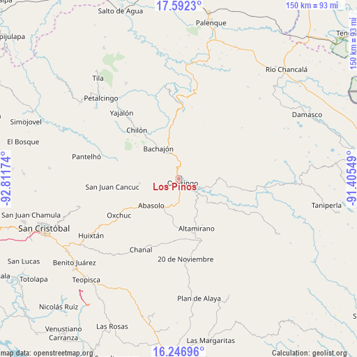
Los Pinos GPS coordinates[2]
16° 55' 14.988" North, 92° 6' 30.996" West
| Map corner | latitude | longitude |
|---|---|---|
| Upper-left | 17.5923°, | -92.81174° |
| Center: | 16.92083°, | -92.10861° |
| Lower-right: | 16.24696°, | -91.40549° |
| Map W x H: | 149.6×149.6 km | = 93×93mi |
| max Lat: | 32.7° ⇑90% North |
| Los Pinos: | 16.92083° |
| min Lat: | ⇓10% South 14.53588° |
| min Long | Los Pinos | max Long |
| -117.105° | -92.10861° | -86.73105° |
| W 94.7%⇐ | ⇒5.3% E |
Elevation
Elevation of Los Pinos is 923 m = 3028 ft, and this is 330.7 m = 1085 ft below average elevation for this country.
| Max E: |
3497 m = 11473 ft | 61.2% |
| Avg. | 1253.7 m = 4113 ft | |
| Los Pinos | 923 m = 3028 ft | |
Min E: |
-1 m = -3 ft | 38.8% |
See also: Mexico elevation on elevation.city.
Geographical zone
Los Pinos is located in North Torrid zone (between Equator and Tropic of Cancer). Distance of this Northern Tropic circle is 724.5 km =450.2 mi to North.| Distance of | km | miles | from Los Pinos |
|---|---|---|---|
| North Pole | 8125.6 | 5049 | to North |
| Arctic Circle | 5519.8 | 3429.8 | to North |
| Tropic Cancer | 724.5 | 450.2 | to North |
| Equator | 1881.4 | 1169 | to South |


Nearby cities:
15 places around Los Pinos: (largest is in red/bold)
• Altamirano
6.1 km =3.8 mi,  226°
226°
• Cuxuljá
13.8 km =8.6 mi,  208°
208°
• El Carmen
12.8 km =8 mi,  36°
36°
• Joaquín Miguel Gutiérrez
13.9 km =8.6 mi,  145°
145°
• Joybé
11.9 km =7.4 mi,  336°
336°
• La Virginia
8.5 km =5.3 mi,  235°
235°
• Mequeja
14.1 km =8.8 mi,  286°
286°
• Nuevo Jerusalén
9.2 km =5.7 mi,  107°
107°
• Nuevo Paraíso
5.3 km =3.3 mi,  131°
131°
• Ocosingo
2.3 km =1.4 mi,  135°
135°
• Palomar 2
14.7 km =9.1 mi,  223°
223°
• Patria Nueva (San José el Contento)
0.9 km =0.6 mi,  325°
325°
• San Marcos
11.7 km =7.3 mi, 290°
• Sibacá
3.5 km =2.2 mi, 288°
• Tzobojitle Jotoaquil
10.8 km =6.7 mi,  25°
25°
Sources, notices
• [Note1] Compared only with cities in Mexico existing in our database
• [Src1] Map data: © OpenStreetMap contributors (CC-BY-SA)
• [Src2] Other city data from geonames.org with taken over terms of usage.
• [Src3] Geographical zone / Annual Mean Temperature by Robert A. Rohde @ Wikipedia
