Buena Vista geodata
Buena Vista (Puebla) is a populated place; located in Mexico in America/Mexico_City (GMT-6) time zone. With population of 534 people, there are 15868 cities with bigger population in this country. Compared to other cities in Mexico, 55.1% of cities are located further ↓South; 69.8% of cities are located further ←West and 57% of cities have lower elevation than Buena Vista. Note1


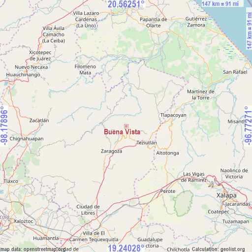
Buena Vista GPS coordinates[2]
19° 54' 10.008" North, 97° 28' 32.988" West
| Map corner | latitude | longitude |
|---|---|---|
| Upper-left | 20.56251°, | -98.17896° |
| Center: | 19.90278°, | -97.47583° |
| Lower-right: | 19.24028°, | -96.77271° |
| Map W x H: | 147×147 km | = 91.3×91.3mi |
| max Lat: | 32.7° ⇑44.9% North |
| Buena Vista: | 19.90278° |
| min Lat: | ⇓55.1% South 14.53588° |
| min Long | Buena Vista | max Long |
| -117.105° | -97.47583° | -86.73105° |
| W 69.8%⇐ | ⇒30.2% E |
Elevation
Elevation of Buena Vista is 1660 m = 5446 ft, and this is 406.3 m = 1333 ft above average elevation for this country.
| Max E: |
3497 m = 11473 ft | 43% |
| Buena Vista | 1660 m 5446 ft | |
| Avg. | 1253.7 m = 4113 ft | |
Min E: |
-1 m = -3 ft | 57% |
See also: Mexico elevation on elevation.city.
Geographical zone
Buena Vista is located in North Torrid zone (between Equator and Tropic of Cancer). Distance of this Northern Tropic circle is 392.9 km =244.1 mi to North.| Distance of | km | miles | from Buena Vista |
|---|---|---|---|
| North Pole | 7794.1 | 4843 | to North |
| Arctic Circle | 5188.2 | 3223.8 | to North |
| Tropic Cancer | 392.9 | 244.1 | to North |
| Equator | 2213 | 1375.1 | to South |


Nearby cities:
15 places around Buena Vista: (largest is in red/bold)
• Acocogta
3.3 km =2.1 mi,  179°
179°
• Ahuatepec
5.8 km =3.6 mi,  127°
127°
• Atalpa
6.2 km =3.9 mi,  207°
207°
• Ciudad de Tlatlauquitepec
5.9 km =3.7 mi,  200°
200°
• Huaxtla
6.9 km =4.3 mi, 204°
• Hueyapán
3.9 km =2.4 mi,  124°
124°
• Ilita
6 km =3.7 mi, 176°
• La Unión
1.1 km =0.7 mi,  7°
7°
• Nexpan
5.9 km =3.7 mi,  110°
110°
• Pezmatlán
6.3 km =3.9 mi,  189°
189°
• Tamalayo
3.3 km =2.1 mi,  343°
343°
• Tanamacoyan
5 km =3.1 mi, 105°
• Teteles de Avila Castillo
5.4 km =3.4 mi,  158°
158°
• Tlatlauquitepec
6.5 km =4 mi, 200°
• Yaonahuac
3.7 km =2.3 mi, 163°
Sources, notices
• [Note1] Compared only with cities in Mexico existing in our database
• [Src1] Map data: © OpenStreetMap contributors (CC-BY-SA)
• [Src2] Other city data from geonames.org with taken over terms of usage.
• [Src3] Geographical zone / Annual Mean Temperature by Robert A. Rohde @ Wikipedia
