Nexpan geodata
Nexpan (Puebla) is a populated place; located in Mexico in America/Mexico_City (GMT-6) time zone. With population of 1,095 people, there are 7940 cities with bigger population in this country. Compared to other cities in Mexico, 54.8% of cities are located further ↓South; 70.3% of cities are located further ←West and 56.2% of cities have lower elevation than Nexpan. Note1


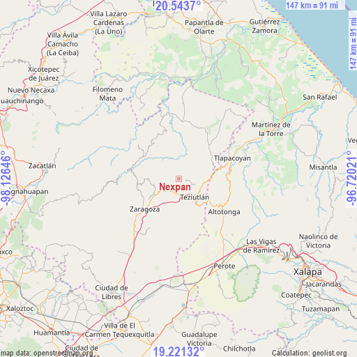
Nexpan GPS coordinates[2]
19° 53' 2.004" North, 97° 25' 23.988" West
| Map corner | latitude | longitude |
|---|---|---|
| Upper-left | 20.5437°, | -98.12646° |
| Center: | 19.88389°, | -97.42333° |
| Lower-right: | 19.22132°, | -96.72021° |
| Map W x H: | 147×147 km | = 91.3×91.3mi |
| max Lat: | 32.7° ⇑45.2% North |
| Nexpan: | 19.88389° |
| min Lat: | ⇓54.8% South 14.53588° |
| min Long | Nexpan | max Long |
| -117.105° | -97.42333° | -86.73105° |
| W 70.3%⇐ | ⇒29.7% E |
Elevation
Elevation of Nexpan is 1627 m = 5338 ft, and this is 373.3 m = 1225 ft above average elevation for this country.
| Max E: |
3497 m = 11473 ft | 43.8% |
| Nexpan | 1627 m 5338 ft | |
| Avg. | 1253.7 m = 4113 ft | |
Min E: |
-1 m = -3 ft | 56.2% |
See also: Mexico elevation on elevation.city.
Geographical zone
Nexpan is located in North Torrid zone (between Equator and Tropic of Cancer). Distance of this Northern Tropic circle is 395 km =245.4 mi to North.| Distance of | km | miles | from Nexpan |
|---|---|---|---|
| North Pole | 7796.2 | 4844.3 | to North |
| Arctic Circle | 5190.3 | 3225.1 | to North |
| Tropic Cancer | 395 | 245.4 | to North |
| Equator | 2210.9 | 1373.8 | to South |


Nearby cities:
15 places around Nexpan: (largest is in red/bold)
• Acocogta
5.6 km =3.5 mi,  257°
257°
• Ahuatepec
1.6 km =1 mi,  212°
212°
• Aire Libre
3 km =1.9 mi,  103°
103°
• Buena Vista
5.9 km =3.7 mi,  290°
290°
• Cala Norte
4 km =2.5 mi,  179°
179°
• Cala Sur
5.7 km =3.5 mi, 177°
• Coacalco
2.9 km =1.8 mi,  187°
187°
• Hueyapán
2.3 km =1.4 mi,  266°
266°
• Las Delicias
5.7 km =3.5 mi, 205°
• Mexcalcuautla
3.8 km =2.4 mi,  120°
120°
• San Nicolás (Animazco)
5.3 km =3.3 mi, 208°
• Tacopan
5.2 km =3.2 mi, 188°
• Tanamacoyan
1 km =0.6 mi,  317°
317°
• Teteles de Avila Castillo
4.6 km =2.9 mi,  230°
230°
• Yaonahuac
4.7 km =2.9 mi,  251°
251°
Sources, notices
• [Note1] Compared only with cities in Mexico existing in our database
• [Src1] Map data: © OpenStreetMap contributors (CC-BY-SA)
• [Src2] Other city data from geonames.org with taken over terms of usage.
• [Src3] Geographical zone / Annual Mean Temperature by Robert A. Rohde @ Wikipedia
