Cuauhtémoc geodata
Cuauhtémoc (Chiapas) is a populated place; located in Mexico in America/Mexico_City (GMT-6) time zone. With population of 783 people, there are 11148 cities with bigger population in this country. Compared to other cities in Mexico, 96.9% of cities are located further ↑North; 96.1% of cities are located further ←West and 50.1% of cities have lower elevation than Cuauhtémoc. Note1


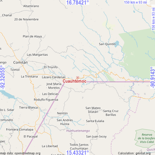
Cuauhtémoc GPS coordinates[2]
16° 6' 35.496" North, 91° 37' 2.712" West
| Map corner | latitude | longitude |
|---|---|---|
| Upper-left | 16.78421°, | -92.32055° |
| Center: | 16.10986°, | -91.61742° |
| Lower-right: | 15.43321°, | -90.9143° |
| Map W x H: | 150.2×150.2 km | = 93.3×93.3mi |
| max Lat: | 32.7° ⇑96.9% North |
| Cuauhtémoc: | 16.10986° |
| min Lat: | ⇓3.1% South 14.53588° |
| min Long | Cuauhtémoc | max Long |
| -117.105° | -91.61742° | -86.73105° |
| W 96.1%⇐ | ⇒3.9% E |
Elevation
Elevation of Cuauhtémoc is 1437 m = 4715 ft, and this is 183.3 m = 601 ft above average elevation for this country.
| Max E: |
3497 m = 11473 ft | 49.9% |
| Cuauhtémoc | 1437 m 4715 ft | |
| Avg. | 1253.7 m = 4113 ft | |
Min E: |
-1 m = -3 ft | 50.1% |
See also: Mexico elevation on elevation.city.
Geographical zone
Cuauhtémoc is located in North Torrid zone (between Equator and Tropic of Cancer). Distance of this Northern Tropic circle is 814.7 km =506.2 mi to North.| Distance of | km | miles | from Cuauhtémoc |
|---|---|---|---|
| North Pole | 8215.8 | 5105.1 | to North |
| Arctic Circle | 5609.9 | 3485.8 | to North |
| Tropic Cancer | 814.7 | 506.2 | to North |
| Equator | 1791.2 | 1113 | to South |


Nearby cities:
15 places around Cuauhtémoc: (largest is in red/bold)
• Amparo Agua Tinta
13.8 km =8.6 mi,  78°
78°
• Carmen Xhán
16.5 km =10.3 mi,  243°
243°
• Miguel Hidalgo
17.2 km =10.7 mi,  267°
267°
• Nuevo San Juan Chamula
18.9 km =11.7 mi, 78°
• Ojo de Agua
15.9 km =9.9 mi,  289°
289°
• Playa Azul
8.1 km =5 mi,  7°
7°
• Río Blanco
10.7 km =6.6 mi,  350°
350°
• San Agustín
14.2 km =8.8 mi, 6°
• San Antonio Buenavista
5.9 km =3.7 mi,  323°
323°
• San Antonio Porvenir
14.9 km =9.3 mi,  328°
328°
• San Antonio los Montes
16.5 km =10.3 mi,  47°
47°
• San Isidro el Zapotal
5.3 km =3.3 mi,  3°
3°
• Santa Rita el Vergel
19.8 km =12.3 mi, 324°
• Tierra y Libertad
7.8 km =4.8 mi, 334°
• Tziscao
6.1 km =3.8 mi, 238°
Sources, notices
• [Note1] Compared only with cities in Mexico existing in our database
• [Src1] Map data: © OpenStreetMap contributors (CC-BY-SA)
• [Src2] Other city data from geonames.org with taken over terms of usage.
• [Src3] Geographical zone / Annual Mean Temperature by Robert A. Rohde @ Wikipedia
