Tierra y Libertad geodata
Tierra y Libertad (Chiapas) is a populated place; located in Mexico in America/Mexico_City (GMT-6) time zone. With population of 582 people, there are 14734 cities with bigger population in this country. Compared to other cities in Mexico, 96.5% of cities are located further ↑North; 96% of cities are located further ←West and 55.4% of cities have higher elevation than Tierra y Libertad. Note1


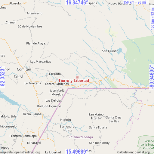
Tierra y Libertad GPS coordinates[2]
16° 10' 23.988" North, 91° 38' 57.012" West
| Map corner | latitude | longitude |
|---|---|---|
| Upper-left | 16.84746°, | -92.3523° |
| Center: | 16.17333°, | -91.64917° |
| Lower-right: | 15.49689°, | -90.94605° |
| Map W x H: | 150.2×150.2 km | = 93.3×93.3mi |
| max Lat: | 32.7° ⇑96.5% North |
| Tierra y Libertad: | 16.17333° |
| min Lat: | ⇓3.5% South 14.53588° |
| min Long | Tierra y Libert | max Long |
| -117.105° | -91.64917° | -86.73105° |
| W 96%⇐ | ⇒4% E |
Elevation
Elevation of Tierra y Libertad is 1184 m = 3885 ft, and this is 69.7 m = 229 ft below average elevation for this country.
| Max E: |
3497 m = 11473 ft | 55.4% |
| Avg. | 1253.7 m = 4113 ft | |
| Tierra y Libertad | 1184 m = 3885 ft | |
Min E: |
-1 m = -3 ft | 44.6% |
See also: Mexico elevation on elevation.city.
Geographical zone
Tierra y Libertad is located in North Torrid zone (between Equator and Tropic of Cancer). Distance of this Northern Tropic circle is 807.6 km =501.8 mi to North.| Distance of | km | miles | from Tierra y Libertad |
|---|---|---|---|
| North Pole | 8208.8 | 5100.7 | to North |
| Arctic Circle | 5602.9 | 3481.5 | to North |
| Tropic Cancer | 807.6 | 501.8 | to North |
| Equator | 1798.3 | 1117.4 | to South |


Nearby cities:
15 places around Tierra y Libertad: (largest is in red/bold)
• Cuauhtémoc
7.8 km =4.8 mi,  154°
154°
• El Edén
13.2 km =8.2 mi,  5°
5°
• El Paraíso
15.2 km =9.4 mi,  319°
319°
• Miguel Hidalgo
15.8 km =9.8 mi,  240°
240°
• Ojo de Agua
11.7 km =7.3 mi,  261°
261°
• Playa Azul
4.5 km =2.8 mi,  77°
77°
• Río Blanco
3.9 km =2.4 mi,  24°
24°
• San Agustín
8.6 km =5.3 mi,  35°
35°
• San Antonio Buenavista
2.3 km =1.4 mi,  182°
182°
• San Antonio Porvenir
7.2 km =4.5 mi, 321°
• San Antonio los Montes
16.1 km =10 mi, 75°
• San Isidro el Zapotal
4.1 km =2.5 mi,  114°
114°
• Santa Elena
16.3 km =10.1 mi,  300°
300°
• Santa Rita el Vergel
12.2 km =7.6 mi, 317°
• Tziscao
10.4 km =6.5 mi,  190°
190°
Sources, notices
• [Note1] Compared only with cities in Mexico existing in our database
• [Src1] Map data: © OpenStreetMap contributors (CC-BY-SA)
• [Src2] Other city data from geonames.org with taken over terms of usage.
• [Src3] Geographical zone / Annual Mean Temperature by Robert A. Rohde @ Wikipedia
