Balsa Larga geodata
Balsa Larga (Veracruz) is a populated place; located in Mexico in America/Mexico_City (GMT-6) time zone. With population of 520 people, there are 16208 cities with bigger population in this country. Compared to other cities in Mexico, 70.1% of cities are located further ↑North; 77.7% of cities are located further ←West and 71.1% of cities have higher elevation than Balsa Larga. Note1


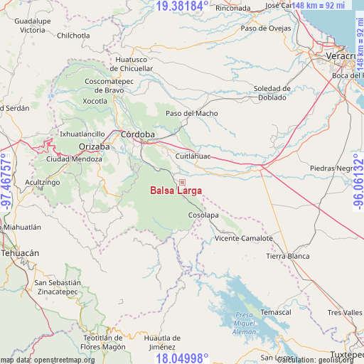
Balsa Larga GPS coordinates[2]
18° 43' 1.992" North, 96° 45' 51.984" West
| Map corner | latitude | longitude |
|---|---|---|
| Upper-left | 19.38184°, | -97.46757° |
| Center: | 18.71722°, | -96.76444° |
| Lower-right: | 18.04998°, | -96.06132° |
| Map W x H: | 148.1×148.1 km | = 92×92mi |
| max Lat: | 32.7° ⇑70.1% North |
| Balsa Larga: | 18.71722° |
| min Lat: | ⇓29.9% South 14.53588° |
| min Long | Balsa Larga | max Long |
| -117.105° | -96.76444° | -86.73105° |
| W 77.7%⇐ | ⇒22.3% E |
Elevation
Elevation of Balsa Larga is 364 m = 1194 ft, and this is 889.7 m = 2919 ft below average elevation for this country.
| Max E: |
3497 m = 11473 ft | 71.1% |
| Avg. | 1253.7 m = 4113 ft | |
| Balsa Larga | 364 m = 1194 ft | |
Min E: |
-1 m = -3 ft | 28.9% |
See also: Mexico elevation on elevation.city.
Geographical zone
Balsa Larga is located in North Torrid zone (between Equator and Tropic of Cancer). Distance of this Northern Tropic circle is 524.8 km =326.1 mi to North.| Distance of | km | miles | from Balsa Larga |
|---|---|---|---|
| North Pole | 7925.9 | 4924.9 | to North |
| Arctic Circle | 5320 | 3305.7 | to North |
| Tropic Cancer | 524.8 | 326.1 | to North |
| Equator | 2081.2 | 1293.2 | to South |


Nearby cities:
15 places around Balsa Larga: (largest is in red/bold)
• Colonia Agrícola Rincón de las Flores
8.8 km =5.5 mi,  271°
271°
• Cruz Tetela
4.9 km =3 mi,  128°
128°
• El Jobo
1.7 km =1.1 mi,  311°
311°
• Emiliano Zapata
2.7 km =1.7 mi,  107°
107°
• La Providencia
4 km =2.5 mi,  350°
350°
• Mata Naranjo
8.6 km =5.3 mi,  38°
38°
• Omealca
4 km =2.5 mi,  326°
326°
• Paso del Rosario
5.9 km =3.7 mi,  70°
70°
• Pocitos
3 km =1.9 mi,  232°
232°
• Presidio (Plan de Libres)
4.2 km =2.6 mi,  190°
190°
• San José de Abajo
6.7 km =4.2 mi, 348°
• Tepecoxtla
7.3 km =4.5 mi,  278°
278°
• Toluquilla Buena Vista
3.9 km =2.4 mi,  33°
33°
• Xonotla
5.9 km =3.7 mi, 267°
• Xuchiles
7.6 km =4.7 mi, 308°
Sources, notices
• [Note1] Compared only with cities in Mexico existing in our database
• [Src1] Map data: © OpenStreetMap contributors (CC-BY-SA)
• [Src2] Other city data from geonames.org with taken over terms of usage.
• [Src3] Geographical zone / Annual Mean Temperature by Robert A. Rohde @ Wikipedia
