NCP Álvaro Obregón geodata
NCP Álvaro Obregón (Tlaxcala) is a populated place; located in Mexico in America/Mexico_City (GMT-6) time zone. With population of 518 people, there are 16254 cities with bigger population in this country. Compared to other cities in Mexico, 52.3% of cities are located further ↑North; 58.2% of cities are located further ←West and 93.2% of cities have lower elevation than NCP Álvaro Obregón. Note1


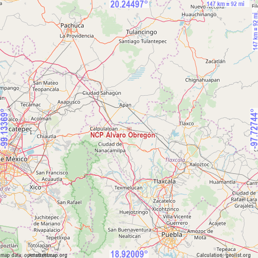
NCP Álvaro Obregón GPS coordinates[2]
19° 35' 2.004" North, 98° 25' 50.016" West
| Map corner | latitude | longitude |
|---|---|---|
| Upper-left | 20.24497°, | -99.13369° |
| Center: | 19.58389°, | -98.43056° |
| Lower-right: | 18.92009°, | -97.72744° |
| Map W x H: | 147.3×147.3 km | = 91.5×91.5mi |
| max Lat: | 32.7° ⇑52.3% North |
| NCP Álvaro Obregón: | 19.58389° |
| min Lat: | ⇓47.7% South 14.53588° |
| min Long | NCP Álvaro Obr | max Long |
| -117.105° | -98.43056° | -86.73105° |
| W 58.2%⇐ | ⇒41.8% E |
Elevation
Elevation of NCP Álvaro Obregón is 2540 m = 8333 ft, and this is 1286.3 m = 4220 ft above average elevation for this country.
| Max E: |
3497 m = 11473 ft | 6.8% |
| NCP Álvaro Obregón | 2540 m 8333 ft | |
| Avg. | 1253.7 m = 4113 ft | |
Min E: |
-1 m = -3 ft | 93.2% |
See also: Mexico elevation on elevation.city.
Geographical zone
NCP Álvaro Obregón is located in North Torrid zone (between Equator and Tropic of Cancer). Distance of this Northern Tropic circle is 428.4 km =266.2 mi to North.| Distance of | km | miles | from NCP Álvaro Obregón |
|---|---|---|---|
| North Pole | 7829.5 | 4865 | to North |
| Arctic Circle | 5223.6 | 3245.8 | to North |
| Tropic Cancer | 428.4 | 266.2 | to North |
| Equator | 2177.5 | 1353 | to South |


Nearby cities:
15 places around NCP Álvaro Obregón: (largest is in red/bold)
• Benito Juárez
0.3 km =0.2 mi,  47°
47°
• Chimalpa y Tlalayote
12.4 km =7.7 mi,  316°
316°
• Domingo Arenas (La Calera)
8.8 km =5.5 mi,  211°
211°
• Francisco I. Madero
9.4 km =5.8 mi,  221°
221°
• Francisco Villa
3.3 km =2.1 mi,  274°
274°
• Ignacio Zaragoza
5.7 km =3.5 mi,  106°
106°
• Jiquilpan
6.6 km =4.1 mi,  42°
42°
• La Magdalena Soltepec
12.3 km =7.6 mi,  91°
91°
• Lázaro Cárdenas
7.6 km =4.7 mi,  325°
325°
• Ocotepec
12.5 km =7.8 mi,  358°
358°
• Ocotepec de Morelos
11.3 km =7 mi,  28°
28°
• San Juan Ixtilmaco
9.4 km =5.8 mi,  347°
347°
• San Lorenzo Sóltepec
12.5 km =7.8 mi,  79°
79°
• Sanctórum
10.9 km =6.8 mi,  203°
203°
• Zotoluca
8.9 km =5.5 mi,  289°
289°
Sources, notices
• [Note1] Compared only with cities in Mexico existing in our database
• [Src1] Map data: © OpenStreetMap contributors (CC-BY-SA)
• [Src2] Other city data from geonames.org with taken over terms of usage.
• [Src3] Geographical zone / Annual Mean Temperature by Robert A. Rohde @ Wikipedia
