Ocotepec geodata
Ocotepec (Hidalgo) is a populated place; located in Mexico in America/Mexico_City (GMT-6) time zone. With population of 794 people, there are 10982 cities with bigger population in this country. Compared to other cities in Mexico, 50.3% of cities are located further ↓South; 58.2% of cities are located further ←West and 92.9% of cities have lower elevation than Ocotepec. Note1


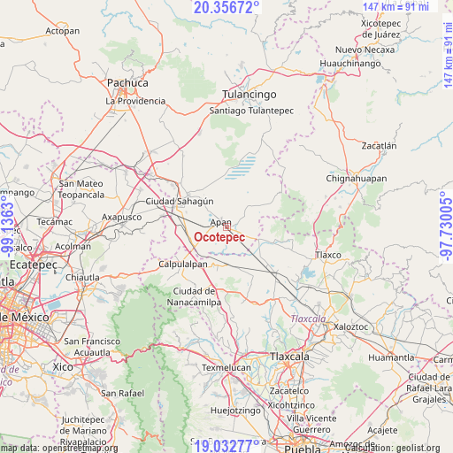
Ocotepec GPS coordinates[2]
19° 41' 45.996" North, 98° 25' 59.412" West
| Map corner | latitude | longitude |
|---|---|---|
| Upper-left | 20.35672°, | -99.1363° |
| Center: | 19.69611°, | -98.43317° |
| Lower-right: | 19.03277°, | -97.73005° |
| Map W x H: | 147.2×147.2 km | = 91.5×91.5mi |
| max Lat: | 32.7° ⇑49.7% North |
| Ocotepec: | 19.69611° |
| min Lat: | ⇓50.3% South 14.53588° |
| min Long | Ocotepec | max Long |
| -117.105° | -98.43317° | -86.73105° |
| W 58.2%⇐ | ⇒41.8% E |
Elevation
Elevation of Ocotepec is 2521 m = 8271 ft, and this is 1267.3 m = 4158 ft above average elevation for this country.
| Max E: |
3497 m = 11473 ft | 7.1% |
| Ocotepec | 2521 m 8271 ft | |
| Avg. | 1253.7 m = 4113 ft | |
Min E: |
-1 m = -3 ft | 92.9% |
See also: Mexico elevation on elevation.city.
Geographical zone
Ocotepec is located in North Torrid zone (between Equator and Tropic of Cancer). Distance of this Northern Tropic circle is 415.9 km =258.4 mi to North.| Distance of | km | miles | from Ocotepec |
|---|---|---|---|
| North Pole | 7817.1 | 4857.3 | to North |
| Arctic Circle | 5211.2 | 3238.1 | to North |
| Tropic Cancer | 415.9 | 258.4 | to North |
| Equator | 2190 | 1360.8 | to South |


Nearby cities:
15 places around Ocotepec: (largest is in red/bold)
• Acopinalco
10.5 km =6.5 mi,  278°
278°
• Almoloya
3.2 km =2 mi,  73°
73°
• Apan
2.5 km =1.6 mi,  312°
312°
• Chimalpa y Tlalayote
9 km =5.6 mi,  247°
247°
• Colonia 20 de Noviembre
11.2 km =7 mi,  316°
316°
• Jiquilpan
9 km =5.6 mi,  148°
148°
• La Laguna
8.2 km =5.1 mi,  301°
301°
• Lomas del Pedregal
8.3 km =5.2 mi, 312°
• Los Voladores
6.6 km =4.1 mi,  255°
255°
• Lázaro Cárdenas
7.4 km =4.6 mi,  213°
213°
• Ocotepec de Morelos
6.2 km =3.9 mi,  114°
114°
• San Juan Ixtilmaco
3.7 km =2.3 mi, 207°
• Santiago Tetlapayac
10.5 km =6.5 mi,  93°
93°
• Tepepatlaxco
9 km =5.6 mi,  45°
45°
• Unión Ejidal Tierra y Libertad
10.9 km =6.8 mi, 113°
Sources, notices
• [Note1] Compared only with cities in Mexico existing in our database
• [Src1] Map data: © OpenStreetMap contributors (CC-BY-SA)
• [Src2] Other city data from geonames.org with taken over terms of usage.
• [Src3] Geographical zone / Annual Mean Temperature by Robert A. Rohde @ Wikipedia
