Taiping geodata
Taiping (Perak) is a populated place; located in Malaysia in Asia/Kuala_Lumpur (GMT+8) time zone. With population of 217,647 people, there are 19 cities with bigger population in this country. Compared to other cities in Malaysia, 61.8% of cities are located further ↓South; 79.2% of cities are located further →East and 60.1% of cities have lower elevation than Taiping. Note1


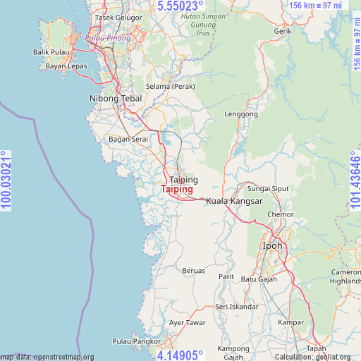
Taiping GPS coordinates[2]
4° 51' 0" North, 100° 43' 59.988" East
| Map corner | latitude | longitude |
|---|---|---|
| Upper-left | 5.55023°, | 100.03021° |
| Center: | 4.85°, | 100.73333° |
| Lower-right: | 4.14905°, | 101.43646° |
| Map W x H: | 155.8×155.8 km | = 96.8×96.8mi |
| max Lat: | 6.88732° ⇑38.2% North |
| Taiping: | 4.85° |
| min Lat: | ⇓61.8% South 1.24722° |
| min Long | Taiping | max Long |
| 99.68252° | 100.73333° | 118.61119° |
| W 20.8%⇐ | ⇒79.2% E |
Elevation
Elevation of Taiping is 19 m = 62 ft, and this is 25.7 m = 84 ft below average elevation for this country.
| Max E: |
1488 m = 4882 ft | 39.9% |
| Avg. | 44.7 m = 147 ft | |
| Taiping | 19 m = 62 ft | |
Min E: |
0 m = 0 ft | 60.1% |
See also: Taiping elevation on elevation.city.
Geographical zone
Taiping is located in North Torrid zone (between Equator and Tropic of Cancer). Distance of Equator is 539.3 km =335.1 mi to South.| Distance of | km | miles | from Taiping |
|---|---|---|---|
| North Pole | 9467.8 | 5883 | to North |
| Arctic Circle | 6861.9 | 4263.8 | to North |
| Tropic Cancer | 2066.6 | 1284.1 | to North |
| Equator | 539.3 | 335.1 | to South |


Nearby cities:
15 places around Taiping: (largest is in red/bold)
• Bagan Serai
27.8 km =17.3 mi,  310°
310°
• Batu Gajah
54.4 km =33.8 mi,  141°
141°
• Bukit Mertajam
64.2 km =39.9 mi,  332°
332°
• Butterworth
73.5 km =45.7 mi, 326°
• Ipoh
48.7 km =30.3 mi,  127°
127°
• Juru
60.6 km =37.7 mi, 327°
• Kampung Sungai Ara
73.5 km =45.7 mi,  316°
316°
• Kuala Kangsar
24 km =14.9 mi,  112°
112°
• Kulim
60.3 km =37.5 mi,  341°
341°
• Lumut
69.6 km =43.2 mi,  189°
189°
• Nibong Tebal
45.1 km =28 mi, 321°
• Pantai Remis
45.3 km =28.1 mi, 194°
• Parit Buntar
40.7 km =25.3 mi, 319°
• Perai
70.8 km =44 mi, 326°
• Simpang Empat
15.7 km =9.8 mi, 315°
Sources, notices
• [Note1] Compared only with cities in Malaysia existing in our database
• [Src1] Map data: © OpenStreetMap contributors (CC-BY-SA)
• [Src2] Other city data from geonames.org with taken over terms of usage.
• [Src3] Geographical zone / Annual Mean Temperature by Robert A. Rohde @ Wikipedia
