Ipoh geodata
Ipoh (Perak) is a seat of a first-order administrative division; located in Malaysia in Asia/Kuala_Lumpur (GMT+8) time zone. With population of 673,318 people, there are 6 cities with bigger population in this country. Compared to other cities in Malaysia, 59.6% of cities are located further ↓South; 75.8% of cities are located further →East and 84.3% of cities have lower elevation than Ipoh. Note1


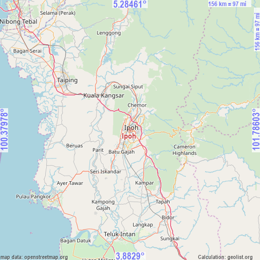
Ipoh GPS coordinates[2]
4° 35' 2.76" North, 101° 4' 58.44" East
| Map corner | latitude | longitude |
|---|---|---|
| Upper-left | 5.28461°, | 100.37978° |
| Center: | 4.5841°, | 101.0829° |
| Lower-right: | 3.8829°, | 101.78603° |
| Map W x H: | 155.9×155.9 km | = 96.9×96.9mi |
| max Lat: | 6.88732° ⇑40.4% North |
| Ipoh: | 4.5841° |
| min Lat: | ⇓59.6% South 1.24722° |
| min Long | Ipoh | max Long |
| 99.68252° | 101.0829° | 118.61119° |
| W 24.2%⇐ | ⇒75.8% E |
Elevation
Elevation of Ipoh is 45 m = 148 ft, and this is 0.3 m = 1 ft above average elevation for this country.
| Max E: |
1488 m = 4882 ft | 15.7% |
| Ipoh | 45 m 148 ft | |
| Avg. | 44.7 m = 147 ft | |
Min E: |
0 m = 0 ft | 84.3% |
See also: Ipoh elevation on elevation.city.
Geographical zone
Ipoh is located in North Torrid zone (between Equator and Tropic of Cancer). Distance of Equator is 509.7 km =316.7 mi to South.| Distance of | km | miles | from Ipoh |
|---|---|---|---|
| North Pole | 9497.4 | 5901.4 | to North |
| Arctic Circle | 6891.5 | 4282.2 | to North |
| Tropic Cancer | 2096.2 | 1302.5 | to North |
| Equator | 509.7 | 316.7 | to South |


Nearby cities:
15 places around Ipoh: (largest is in red/bold)
• Bagan Serai
76.5 km =47.5 mi,  308°
308°
• Batu Gajah
13.6 km =8.5 mi,  199°
199°
• Bidur
56.5 km =35.1 mi,  156°
156°
• Kampar
32.5 km =20.2 mi,  166°
166°
• Kuala Kangsar
26.2 km =16.3 mi,  320°
320°
• Lumut
63.7 km =39.6 mi,  232°
232°
• Nibong Tebal
93.1 km =57.8 mi, 313°
• Pantai Remis
52.3 km =32.5 mi,  254°
254°
• Parit Buntar
88.9 km =55.2 mi, 312°
• Sabak Bernam
91.2 km =56.7 mi,  186°
186°
• Simpang Empat
64.3 km =40 mi, 309°
• Taiping
48.7 km =30.3 mi, 307°
• Tanah Rata
35.2 km =21.9 mi,  112°
112°
• Tapah Road
48.2 km =30 mi, 164°
• Teluk Intan
62.9 km =39.1 mi, 186°
Sources, notices
• [Note1] Compared only with cities in Malaysia existing in our database
• [Src1] Map data: © OpenStreetMap contributors (CC-BY-SA)
• [Src2] Other city data from geonames.org with taken over terms of usage.
• [Src3] Geographical zone / Annual Mean Temperature by Robert A. Rohde @ Wikipedia
