Buloh Kasap geodata
Buloh Kasap (Johor) is a populated place; located in Malaysia in Asia/Kuala_Lumpur (GMT+8) time zone. With population of 13,088 people, there are 148 cities with bigger population in this country. Compared to other cities in Malaysia, 76.4% of cities are located further ↑North; 66.3% of cities are located further ←West and 61.8% of cities have lower elevation than Buloh Kasap. Note1


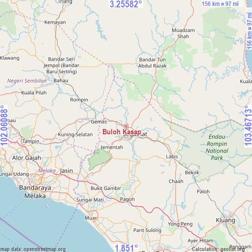
Buloh Kasap GPS coordinates[2]
2° 33' 12.96" North, 102° 45' 50.4" East
| Map corner | latitude | longitude |
|---|---|---|
| Upper-left | 3.25582°, | 102.06088° |
| Center: | 2.5536°, | 102.764° |
| Lower-right: | 1.851°, | 103.46713° |
| Map W x H: | 156.2×156.2 km | = 97.1×97.1mi |
| max Lat: | 6.88732° ⇑76.4% North |
| Buloh Kasap: | 2.5536° |
| min Lat: | ⇓23.6% South 1.24722° |
| min Long | Buloh Kasap | max Long |
| 99.68252° | 102.764° | 118.61119° |
| W 66.3%⇐ | ⇒33.7% E |
Elevation
Elevation of Buloh Kasap is 20 m = 66 ft, and this is 24.7 m = 81 ft below average elevation for this country.
| Max E: |
1488 m = 4882 ft | 38.2% |
| Avg. | 44.7 m = 147 ft | |
| Buloh Kasap | 20 m = 66 ft | |
Min E: |
0 m = 0 ft | 61.8% |
See also: Malaysia elevation on elevation.city.
Geographical zone
Buloh Kasap is located in North Torrid zone (between Equator and Tropic of Cancer). Distance of Equator is 283.9 km =176.4 mi to South.| Distance of | km | miles | from Buloh Kasap |
|---|---|---|---|
| North Pole | 9723.1 | 6041.7 | to North |
| Arctic Circle | 7117.2 | 4422.4 | to North |
| Tropic Cancer | 2322 | 1442.8 | to North |
| Equator | 283.9 | 176.4 | to South |


Nearby cities:
15 places around Buloh Kasap: (largest is in red/bold)
• Alor Gajah
64.6 km =40.1 mi,  252°
252°
• Bahau
48.9 km =30.4 mi,  305°
305°
• Bakri
58 km =36 mi,  192°
192°
• Bemban
53.6 km =33.3 mi,  233°
233°
• Chaah
46.3 km =28.8 mi,  137°
137°
• Kampung Ayer Keroh
62.6 km =38.9 mi,  239°
239°
• Kampung Ayer Molek
61.4 km =38.2 mi, 232°
• Kampung Bukit Baharu
65.2 km =40.5 mi, 234°
• Kuala Pilah
60.8 km =37.8 mi,  289°
289°
• Labis
34.2 km =21.3 mi,  123°
123°
• Muar
60.6 km =37.7 mi,  200°
200°
• Pulau Sebang
60 km =37.3 mi,  259°
259°
• Segamat
7.2 km =4.5 mi,  126°
126°
• Tampin
60 km =37.3 mi, 261°
• Tangkak
40 km =24.9 mi,  217°
217°
Sources, notices
• [Note1] Compared only with cities in Malaysia existing in our database
• [Src1] Map data: © OpenStreetMap contributors (CC-BY-SA)
• [Src2] Other city data from geonames.org with taken over terms of usage.
• [Src3] Geographical zone / Annual Mean Temperature by Robert A. Rohde @ Wikipedia
