Labis geodata
Labis (Johor) is a populated place; located in Malaysia in Asia/Kuala_Lumpur (GMT+8) time zone. With population of 21,906 people, there are 112 cities with bigger population in this country. Compared to other cities in Malaysia, 79.8% of cities are located further ↑North; 68% of cities are located further ←West and 86.5% of cities have lower elevation than Labis. Note1


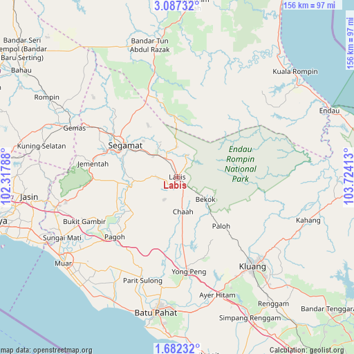
Labis GPS coordinates[2]
2° 23' 6" North, 103° 1' 15.6" East
| Map corner | latitude | longitude |
|---|---|---|
| Upper-left | 3.08732°, | 102.31788° |
| Center: | 2.385°, | 103.021° |
| Lower-right: | 1.68232°, | 103.72413° |
| Map W x H: | 156.2×156.2 km | = 97.1×97.1mi |
| max Lat: | 6.88732° ⇑79.8% North |
| Labis: | 2.385° |
| min Lat: | ⇓20.2% South 1.24722° |
| min Long | Labis | max Long |
| 99.68252° | 103.021° | 118.61119° |
| W 68%⇐ | ⇒32% E |
Elevation
Elevation of Labis is 48 m = 157 ft, and this is 3.3 m = 11 ft above average elevation for this country.
| Max E: |
1488 m = 4882 ft | 13.5% |
| Labis | 48 m 157 ft | |
| Avg. | 44.7 m = 147 ft | |
Min E: |
0 m = 0 ft | 86.5% |
See also: Malaysia elevation on elevation.city.
Geographical zone
Labis is located in North Torrid zone (between Equator and Tropic of Cancer). Distance of Equator is 265.2 km =164.8 mi to South.| Distance of | km | miles | from Labis |
|---|---|---|---|
| North Pole | 9741.9 | 6053.3 | to North |
| Arctic Circle | 7136 | 4434.1 | to North |
| Tropic Cancer | 2340.7 | 1454.4 | to North |
| Equator | 265.2 | 164.8 | to South |


Nearby cities:
15 places around Labis: (largest is in red/bold)
• Bahau
83 km =51.6 mi,  304°
304°
• Bakri
55.8 km =34.7 mi,  227°
227°
• Batu Pahat
59.8 km =37.2 mi,  189°
189°
• Bemban
73 km =45.4 mi,  259°
259°
• Buloh Kasap
34.2 km =21.3 mi, 303°
• Chaah
15.4 km =9.6 mi,  168°
168°
• Kampung Ayer Keroh
83.4 km =51.8 mi, 260°
• Kampung Ayer Molek
79.3 km =49.3 mi, 256°
• Kampung Simpang Renggam
69.3 km =43.1 mi,  153°
153°
• Kluang
51.3 km =31.9 mi,  140°
140°
• Muar
62.9 km =39.1 mi, 232°
• Parit Raja
58.4 km =36.3 mi, 169°
• Segamat
27 km =16.8 mi, 302°
• Tangkak
54.4 km =33.8 mi, 256°
• Yong Peng
41.6 km =25.8 mi, 173°
Sources, notices
• [Note1] Compared only with cities in Malaysia existing in our database
• [Src1] Map data: © OpenStreetMap contributors (CC-BY-SA)
• [Src2] Other city data from geonames.org with taken over terms of usage.
• [Src3] Geographical zone / Annual Mean Temperature by Robert A. Rohde @ Wikipedia
