Bentong Town geodata
Bentong Town (Pahang) is a populated place; located in Malaysia in Asia/Kuala_Lumpur (GMT+8) time zone. With population of 49,213 people, there are 67 cities with bigger population in this country. Compared to other cities in Malaysia, 52.8% of cities are located further ↑North; 55.6% of cities are located further →East and 95.5% of cities have lower elevation than Bentong Town. Note1


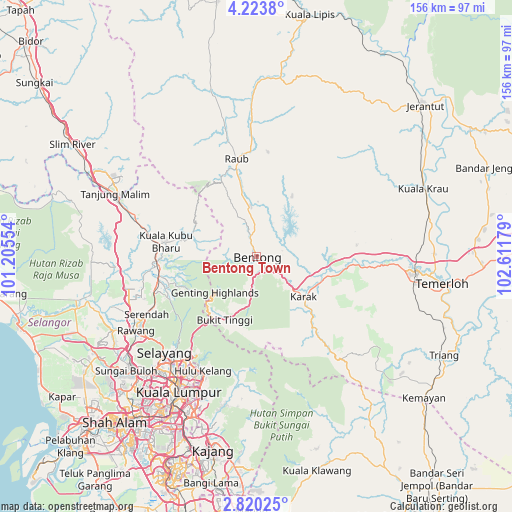
Bentong Town GPS coordinates[2]
3° 31' 20.244" North, 101° 54' 31.176" East
| Map corner | latitude | longitude |
|---|---|---|
| Upper-left | 4.2238°, | 101.20554° |
| Center: | 3.52229°, | 101.90866° |
| Lower-right: | 2.82025°, | 102.61179° |
| Map W x H: | 156.1×156.1 km | = 97×97mi |
| max Lat: | 6.88732° ⇑52.8% North |
| Bentong Town: | 3.52229° |
| min Lat: | ⇓47.2% South 1.24722° |
| min Long | Bentong Town | max Long |
| 99.68252° | 101.90866° | 118.61119° |
| W 44.4%⇐ | ⇒55.6% E |
Elevation
Elevation of Bentong Town is 95 m = 312 ft, and this is 50.3 m = 165 ft above average elevation for this country.
| Max E: |
1488 m = 4882 ft | 4.5% |
| Bentong Town | 95 m 312 ft | |
| Avg. | 44.7 m = 147 ft | |
Min E: |
0 m = 0 ft | 95.5% |
See also: Bentong Town elevation on elevation.city.
Geographical zone
Bentong Town is located in North Torrid zone (between Equator and Tropic of Cancer). Distance of Equator is 391.6 km =243.3 mi to South.| Distance of | km | miles | from Bentong Town |
|---|---|---|---|
| North Pole | 9615.4 | 5974.7 | to North |
| Arctic Circle | 7009.5 | 4355.5 | to North |
| Tropic Cancer | 2214.3 | 1375.9 | to North |
| Equator | 391.6 | 243.3 | to South |


Nearby cities:
15 places around Bentong Town: (largest is in red/bold)
• Ampang
44.3 km =27.5 mi,  200°
200°
• Batang Berjuntai
56.7 km =35.2 mi,  254°
254°
• Batu Arang
54.1 km =33.6 mi, 245°
• Kampong Baharu Balakong
57.1 km =35.5 mi, 197°
• Kampung Baru Subang
58.7 km =36.5 mi,  225°
225°
• Kampung Bukit Tinggi, Bentong
21.3 km =13.2 mi,  205°
205°
• Kuala Lumpur
49 km =30.4 mi, 210°
• Kuang
49 km =30.4 mi, 233°
• Ladang Seri Kundang
50.6 km =31.4 mi,  238°
238°
• Mentekab
49 km =30.4 mi,  94°
94°
• Petaling Jaya
57 km =35.4 mi,  215°
215°
• Raub
30.3 km =18.8 mi,  349°
349°
• Rawang
43.1 km =26.8 mi, 238°
• Serendah
38.1 km =23.7 mi, 242°
• Temerluh
57 km =35.4 mi,  98°
98°
Sources, notices
• [Note1] Compared only with cities in Malaysia existing in our database
• [Src1] Map data: © OpenStreetMap contributors (CC-BY-SA)
• [Src2] Other city data from geonames.org with taken over terms of usage.
• [Src3] Geographical zone / Annual Mean Temperature by Robert A. Rohde @ Wikipedia
