Teluk Intan geodata
Teluk Intan (Perak) is a populated place; located in Malaysia in Asia/Kuala_Lumpur (GMT+8) time zone. With population of 63,353 people, there are 54 cities with bigger population in this country. Compared to other cities in Malaysia, 51.1% of cities are located further ↓South; 77% of cities are located further →East and 96.6% of cities have higher elevation than Teluk Intan. Note1


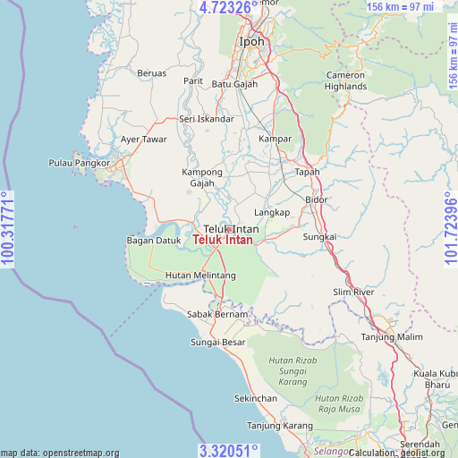
Teluk Intan GPS coordinates[2]
4° 1' 19.884" North, 101° 1' 14.988" East
| Map corner | latitude | longitude |
|---|---|---|
| Upper-left | 4.72326°, | 100.31771° |
| Center: | 4.02219°, | 101.02083° |
| Lower-right: | 3.32051°, | 101.72396° |
| Map W x H: | 156×156 km | = 96.9×96.9mi |
| max Lat: | 6.88732° ⇑48.9% North |
| Teluk Intan: | 4.02219° |
| min Lat: | ⇓51.1% South 1.24722° |
| min Long | Teluk Intan | max Long |
| 99.68252° | 101.02083° | 118.61119° |
| W 23%⇐ | ⇒77% E |
Elevation
Elevation of Teluk Intan is 4 m = 13 ft, and this is 40.7 m = 134 ft below average elevation for this country.
| Max E: |
1488 m = 4882 ft | 96.6% |
| Avg. | 44.7 m = 147 ft | |
| Teluk Intan | 4 m = 13 ft | |
Min E: |
0 m = 0 ft | 3.4% |
See also: Teluk Intan elevation on elevation.city.
Geographical zone
Teluk Intan is located in North Torrid zone (between Equator and Tropic of Cancer). Distance of Equator is 447.2 km =277.9 mi to South.| Distance of | km | miles | from Teluk Intan |
|---|---|---|---|
| North Pole | 9559.8 | 5940.2 | to North |
| Arctic Circle | 6953.9 | 4321 | to North |
| Tropic Cancer | 2158.7 | 1341.4 | to North |
| Equator | 447.2 | 277.9 | to South |


Nearby cities:
15 places around Teluk Intan: (largest is in red/bold)
• Batang Berjuntai
83.5 km =51.9 mi,  148°
148°
• Batu Arang
92.7 km =57.6 mi, 147°
• Batu Gajah
49.7 km =30.9 mi,  2°
2°
• Bidur
31 km =19.3 mi,  70°
70°
• Ipoh
62.9 km =39.1 mi,  6°
6°
• Kampar
34 km =21.1 mi,  24°
24°
• Kampung Tanjung Karang
68.9 km =42.8 mi,  164°
164°
• Kuala Kangsar
83.3 km =51.8 mi,  353°
353°
• Kuala Selangor
78.9 km =49 mi, 161°
• Lumut
49.3 km =30.6 mi,  298°
298°
• Pantai Remis
64.9 km =40.3 mi,  317°
317°
• Sabak Bernam
28.3 km =17.6 mi,  187°
187°
• Sungai Besar
38.8 km =24.1 mi, 185°
• Tanah Rata
62.9 km =39.1 mi,  38°
38°
• Tapah Road
25.6 km =15.9 mi,  51°
51°
Sources, notices
• [Note1] Compared only with cities in Malaysia existing in our database
• [Src1] Map data: © OpenStreetMap contributors (CC-BY-SA)
• [Src2] Other city data from geonames.org with taken over terms of usage.
• [Src3] Geographical zone / Annual Mean Temperature by Robert A. Rohde @ Wikipedia
