Tanah Rata geodata
Tanah Rata (Pahang) is a seat of a second-order administrative division; located in Malaysia in Asia/Kuala_Lumpur (GMT+8) time zone. With population of 7,000 people, there are 160 cities with bigger population in this country. Compared to other cities in Malaysia, 57.3% of cities are located further ↓South; 71.3% of cities are located further →East and 100% of cities have lower elevation than Tanah Rata. Note1


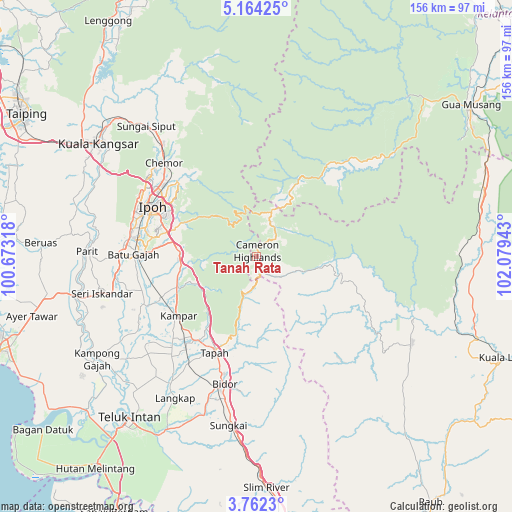
Tanah Rata GPS coordinates[2]
4° 27' 48.996" North, 101° 22' 34.68" East
| Map corner | latitude | longitude |
|---|---|---|
| Upper-left | 5.16425°, | 100.67318° |
| Center: | 4.46361°, | 101.3763° |
| Lower-right: | 3.7623°, | 102.07943° |
| Map W x H: | 155.9×155.9 km | = 96.9×96.9mi |
| max Lat: | 6.88732° ⇑42.7% North |
| Tanah Rata: | 4.46361° |
| min Lat: | ⇓57.3% South 1.24722° |
| min Long | Tanah Rata | max Long |
| 99.68252° | 101.3763° | 118.61119° |
| W 28.7%⇐ | ⇒71.3% E |
Elevation
Elevation of Tanah Rata is 1488 m = 4882 ft, and this is 1443.3 m = 4735 ft above average elevation for this country.
| Max E: |
1488 m = 4882 ft | 0% |
| Tanah Rata | 1488 m 4882 ft | |
| Avg. | 44.7 m = 147 ft | |
Min E: |
0 m = 0 ft | 100% |
See also: Malaysia elevation on elevation.city.
Geographical zone
Tanah Rata is located in North Torrid zone (between Equator and Tropic of Cancer). Distance of Equator is 496.3 km =308.4 mi to South.| Distance of | km | miles | from Tanah Rata |
|---|---|---|---|
| North Pole | 9510.8 | 5909.7 | to North |
| Arctic Circle | 6904.9 | 4290.5 | to North |
| Tropic Cancer | 2109.6 | 1310.8 | to North |
| Equator | 496.3 | 308.4 | to South |


Nearby cities:
15 places around Tanah Rata: (largest is in red/bold)
• Batu Gajah
37.2 km =23.1 mi,  270°
270°
• Bidur
39.9 km =24.8 mi,  194°
194°
• Gua Musang
80.6 km =50.1 mi,  54°
54°
• Ipoh
35.2 km =21.9 mi,  292°
292°
• Kampar
31 km =19.3 mi,  234°
234°
• Kuala Kangsar
59.5 km =37 mi,  304°
304°
• Kuala Lipis
80.6 km =50.1 mi,  112°
112°
• Lumut
86.7 km =53.9 mi,  252°
252°
• Pantai Remis
82.9 km =51.5 mi, 269°
• Raub
91.9 km =57.1 mi,  144°
144°
• Sabak Bernam
88.4 km =54.9 mi,  209°
209°
• Sungai Besar
97.8 km =60.8 mi, 206°
• Taiping
83.2 km =51.7 mi, 301°
• Tapah Road
38.4 km =23.9 mi, 210°
• Teluk Intan
62.9 km =39.1 mi,  218°
218°
Sources, notices
• [Note1] Compared only with cities in Malaysia existing in our database
• [Src1] Map data: © OpenStreetMap contributors (CC-BY-SA)
• [Src2] Other city data from geonames.org with taken over terms of usage.
• [Src3] Geographical zone / Annual Mean Temperature by Robert A. Rohde @ Wikipedia
