Temerluh geodata
Temerluh (Pahang) is a populated place; located in Malaysia in Asia/Kuala_Lumpur (GMT+8) time zone. With population of 59,916 people, there are 57 cities with bigger population in this country. Compared to other cities in Malaysia, 54.5% of cities are located further ↑North; 62.4% of cities are located further ←West and 84.3% of cities have lower elevation than Temerluh. Note1


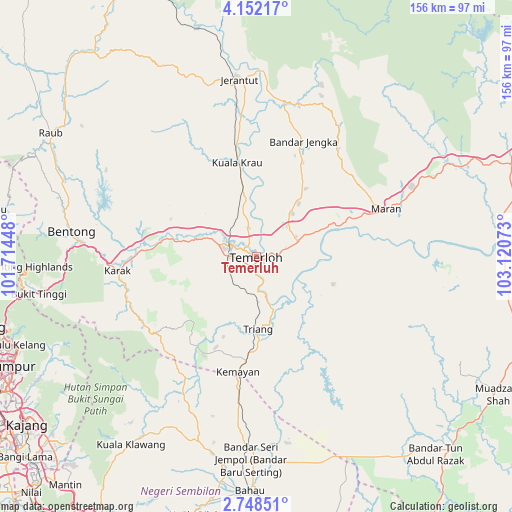
Temerluh GPS coordinates[2]
3° 27' 2.16" North, 102° 25' 3.36" East
| Map corner | latitude | longitude |
|---|---|---|
| Upper-left | 4.15217°, | 101.71448° |
| Center: | 3.4506°, | 102.4176° |
| Lower-right: | 2.74851°, | 103.12073° |
| Map W x H: | 156.1×156.1 km | = 97×97mi |
| max Lat: | 6.88732° ⇑54.5% North |
| Temerluh: | 3.4506° |
| min Lat: | ⇓45.5% South 1.24722° |
| min Long | Temerluh | max Long |
| 99.68252° | 102.4176° | 118.61119° |
| W 62.4%⇐ | ⇒37.6% E |
Elevation
Elevation of Temerluh is 45 m = 148 ft, and this is 0.3 m = 1 ft above average elevation for this country.
| Max E: |
1488 m = 4882 ft | 15.7% |
| Temerluh | 45 m 148 ft | |
| Avg. | 44.7 m = 147 ft | |
Min E: |
0 m = 0 ft | 84.3% |
See also: Temerluh elevation on elevation.city.
Geographical zone
Temerluh is located in North Torrid zone (between Equator and Tropic of Cancer). Distance of Equator is 383.7 km =238.4 mi to South.| Distance of | km | miles | from Temerluh |
|---|---|---|---|
| North Pole | 9623.4 | 5979.7 | to North |
| Arctic Circle | 7017.5 | 4360.5 | to North |
| Tropic Cancer | 2222.2 | 1380.8 | to North |
| Equator | 383.7 | 238.4 | to South |


Nearby cities:
15 places around Temerluh: (largest is in red/bold)
• Ampang
79.6 km =49.5 mi,  245°
245°
• Bahau
71.5 km =44.4 mi,  181°
181°
• Bentong Town
57 km =35.4 mi,  278°
278°
• Jerantut
54.3 km =33.7 mi,  353°
353°
• Kampong Baharu Balakong
87.4 km =54.3 mi,  237°
237°
• Kampung Bukit Tinggi, Bentong
66.6 km =41.4 mi,  260°
260°
• Kuala Lipis
91.4 km =56.8 mi,  333°
333°
• Kuala Lumpur
88.1 km =54.7 mi, 247°
• Kuala Pilah
81.3 km =50.5 mi,  193°
193°
• Mentekab
8.6 km =5.3 mi,  296°
296°
• Raub
72.8 km =45.2 mi, 301°
• Rawang
94.4 km =58.7 mi, 261°
• Semenyih
84.5 km =52.5 mi,  228°
228°
• Seremban
96.2 km =59.8 mi,  213°
213°
• Serendah
90.8 km =56.4 mi, 263°
Sources, notices
• [Note1] Compared only with cities in Malaysia existing in our database
• [Src1] Map data: © OpenStreetMap contributors (CC-BY-SA)
• [Src2] Other city data from geonames.org with taken over terms of usage.
• [Src3] Geographical zone / Annual Mean Temperature by Robert A. Rohde @ Wikipedia
