Wamako geodata
Wamako (Sokoto) is a seat of a second-order administrative division; located in Nigeria in Africa/Lagos (GMT+1) time zone. In our database, there are 451 cities with bigger population. Compared to other cities in Nigeria, 97.1% of cities are located further ↓South; 80.2% of cities are located further →East and 53.4% of cities have higher elevation than Wamako. Note1


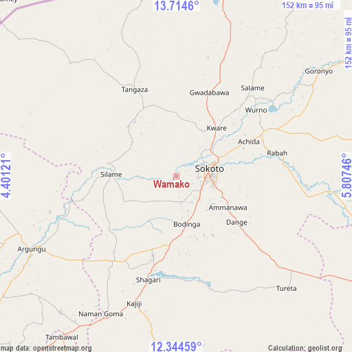
Wamako GPS coordinates[2]
13° 1' 49.944" North, 5° 6' 15.588" East
| Map corner | latitude | longitude |
|---|---|---|
| Upper-left | 13.7146°, | 4.40121° |
| Center: | 13.03054°, | 5.10433° |
| Lower-right: | 12.34459°, | 5.80746° |
| Map W x H: | 152.3×152.3 km | = 94.6×94.6mi |
| max Lat: | 13.7543° ⇑2.9% North |
| Wamako: | 13.03054° |
| min Lat: | ⇓97.1% South 4.31231° |
| min Long | Wamako | max Long |
| 2.73333° | 5.10433° | 14.46552° |
| W 19.8%⇐ | ⇒80.2% E |
Elevation
Elevation of Wamako is 257 m = 843 ft, and this is 39.5 m = 130 ft below average elevation for this country.
| Max E: |
1599 m = 5246 ft | 53.4% |
| Avg. | 296.5 m = 973 ft | |
| Wamako | 257 m = 843 ft | |
Min E: |
2 m = 7 ft | 46.6% |
See also: Nigeria elevation on elevation.city.
Geographical zone
Wamako is located in North Torrid zone (between Equator and Tropic of Cancer). Distance of this Northern Tropic circle is 1157.1 km =719 mi to North.| Distance of | km | miles | from Wamako |
|---|---|---|---|
| North Pole | 8558.2 | 5317.8 | to North |
| Arctic Circle | 5952.3 | 3698.6 | to North |
| Tropic Cancer | 1157.1 | 719 | to North |
| Equator | 1448.9 | 900.3 | to South |


Nearby cities:
15 places around Wamako: (largest is in red/bold)
• Augie
56.9 km =35.4 mi,  254°
254°
• Balle
67 km =41.6 mi,  316°
316°
• Binji
30.1 km =18.7 mi, 315°
• Bodinga
21.3 km =13.2 mi,  166°
166°
• Dange
32.8 km =20.4 mi,  127°
127°
• Gidan Madi
32.7 km =20.3 mi,  334°
334°
• Gwadabawa
39.2 km =24.4 mi,  21°
21°
• Kware
27.4 km =17 mi,  39°
39°
• Rabah
44.9 km =27.9 mi,  76°
76°
• Shagari
46.4 km =28.8 mi,  195°
195°
• Silame
28 km =17.4 mi,  271°
271°
• Sokoto
15.5 km =9.6 mi, 76°
• Tureta
68.1 km =42.3 mi,  135°
135°
• Wurno
45.1 km =28 mi,  50°
50°
• Yabo
35.7 km =22.2 mi, 196°
Sources, notices
• [Note1] Compared only with cities in Nigeria existing in our database
• [Src1] Map data: © OpenStreetMap contributors (CC-BY-SA)
• [Src2] Other city data from geonames.org with taken over terms of usage.
• [Src3] Geographical zone / Annual Mean Temperature by Robert A. Rohde @ Wikipedia
