Wurno geodata
Wurno (Sokoto) is a seat of a second-order administrative division; located in Nigeria in Africa/Lagos (GMT+1) time zone. With population of 13,087 people, there are 272 cities with bigger population in this country. Compared to other cities in Nigeria, 99% of cities are located further ↓South; 76.5% of cities are located further →East and 51.5% of cities have higher elevation than Wurno. Note1


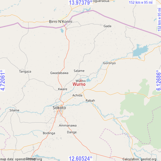
Wurno GPS coordinates[2]
13° 17' 25.728" North, 5° 25' 25.428" East
| Map corner | latitude | longitude |
|---|---|---|
| Upper-left | 13.97379°, | 4.72061° |
| Center: | 13.29048°, | 5.42373° |
| Lower-right: | 12.60524°, | 6.12686° |
| Map W x H: | 152.2×152.2 km | = 94.6×94.6mi |
| max Lat: | 13.7543° ⇑1% North |
| Wurno: | 13.29048° |
| min Lat: | ⇓99% South 4.31231° |
| min Long | Wurno | max Long |
| 2.73333° | 5.42373° | 14.46552° |
| W 23.5%⇐ | ⇒76.5% E |
Elevation
Elevation of Wurno is 273 m = 896 ft, and this is 23.5 m = 77 ft below average elevation for this country.
| Max E: |
1599 m = 5246 ft | 51.5% |
| Avg. | 296.5 m = 973 ft | |
| Wurno | 273 m = 896 ft | |
Min E: |
2 m = 7 ft | 48.5% |
See also: Nigeria elevation on elevation.city.
Geographical zone
Wurno is located in North Torrid zone (between Equator and Tropic of Cancer). Distance of this Northern Tropic circle is 1128.2 km =701 mi to North.| Distance of | km | miles | from Wurno |
|---|---|---|---|
| North Pole | 8529.3 | 5299.9 | to North |
| Arctic Circle | 5923.4 | 3680.6 | to North |
| Tropic Cancer | 1128.2 | 701 | to North |
| Equator | 1477.8 | 918.3 | to South |


Nearby cities:
15 places around Wurno: (largest is in red/bold)
• Binji
56.2 km =34.9 mi,  262°
262°
• Bodinga
57.8 km =35.9 mi,  210°
210°
• Dange
49.4 km =30.7 mi,  189°
189°
• Gada
57.4 km =35.7 mi,  26°
26°
• Gandi
50.2 km =31.2 mi,  136°
136°
• Gidan Madi
48.6 km =30.2 mi,  270°
270°
• Goronyo
31.8 km =19.8 mi,  57°
57°
• Gwadabawa
21.4 km =13.3 mi,  290°
290°
• Illela
50.8 km =31.6 mi,  344°
344°
• Kware
18.8 km =11.7 mi,  245°
245°
• Rabah
20.8 km =12.9 mi,  154°
154°
• Silame
68.5 km =42.6 mi, 245°
• Sokoto
32 km =19.9 mi,  217°
217°
• Wamako
45.1 km =28 mi,  230°
230°
• Yabo
77.3 km =48 mi, 215°
Sources, notices
• [Note1] Compared only with cities in Nigeria existing in our database
• [Src1] Map data: © OpenStreetMap contributors (CC-BY-SA)
• [Src2] Other city data from geonames.org with taken over terms of usage.
• [Src3] Geographical zone / Annual Mean Temperature by Robert A. Rohde @ Wikipedia
