Sokoto geodata
Sokoto is a seat of a first-order administrative division; located in Nigeria in Africa/Lagos (GMT+1) time zone. With population of 563,861 people, there are 15 cities with bigger population in this country. Compared to other cities in Nigeria, 97.6% of cities are located further ↓South; 78% of cities are located further →East and 52.5% of cities have lower elevation than Sokoto. Note1


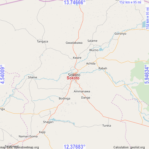
Sokoto GPS coordinates[2]
13° 3' 45.684" North, 5° 14' 35.592" East
| Map corner | latitude | longitude |
|---|---|---|
| Upper-left | 13.74666°, | 4.54009° |
| Center: | 13.06269°, | 5.24322° |
| Lower-right: | 12.37683°, | 5.94634° |
| Map W x H: | 152.3×152.3 km | = 94.6×94.6mi |
| max Lat: | 13.7543° ⇑2.4% North |
| Sokoto: | 13.06269° |
| min Lat: | ⇓97.6% South 4.31231° |
| min Long | Sokoto | max Long |
| 2.73333° | 5.24322° | 14.46552° |
| W 22%⇐ | ⇒78% E |
Elevation
Elevation of Sokoto is 296 m = 971 ft, and this is 0.5 m = 2 ft below average elevation for this country.
| Max E: |
1599 m = 5246 ft | 47.5% |
| Avg. | 296.5 m = 973 ft | |
| Sokoto | 296 m = 971 ft | |
Min E: |
2 m = 7 ft | 52.5% |
See also: Sokoto elevation on elevation.city.
Geographical zone
Sokoto is located in North Torrid zone (between Equator and Tropic of Cancer). Distance of this Northern Tropic circle is 1153.5 km =716.8 mi to North.| Distance of | km | miles | from Sokoto |
|---|---|---|---|
| North Pole | 8554.6 | 5315.6 | to North |
| Arctic Circle | 5948.7 | 3696.3 | to North |
| Tropic Cancer | 1153.5 | 716.8 | to North |
| Equator | 1452.4 | 902.5 | to South |


Nearby cities:
15 places around Sokoto: (largest is in red/bold)
• Binji
40.3 km =25 mi,  296°
296°
• Bodinga
26.3 km =16.3 mi,  202°
202°
• Dange
25.8 km =16 mi,  154°
154°
• Gandi
55.3 km =34.4 mi,  101°
101°
• Gidan Madi
38.9 km =24.2 mi,  311°
311°
• Goronyo
62.8 km =39 mi,  47°
47°
• Gwadabawa
32.9 km =20.4 mi,  359°
359°
• Kware
17.6 km =10.9 mi,  8°
8°
• Rabah
29.4 km =18.3 mi,  76°
76°
• Shagari
55.5 km =34.5 mi,  209°
209°
• Silame
43.1 km =26.8 mi,  266°
266°
• Tureta
61.5 km =38.2 mi, 147°
• Wamako
15.5 km =9.6 mi,  256°
256°
• Wurno
32 km =19.9 mi,  37°
37°
• Yabo
45.3 km =28.1 mi, 213°
Sources, notices
• [Note1] Compared only with cities in Nigeria existing in our database
• [Src1] Map data: © OpenStreetMap contributors (CC-BY-SA)
• [Src2] Other city data from geonames.org with taken over terms of usage.
• [Src3] Geographical zone / Annual Mean Temperature by Robert A. Rohde @ Wikipedia
