Bodinga geodata
Bodinga (Sokoto) is a seat of a second-order administrative division; located in Nigeria in Africa/Lagos (GMT+1) time zone. In our database, there are 451 cities with bigger population. Compared to other cities in Nigeria, 95.1% of cities are located further ↓South; 79.2% of cities are located further →East and 53.8% of cities have lower elevation than Bodinga. Note1


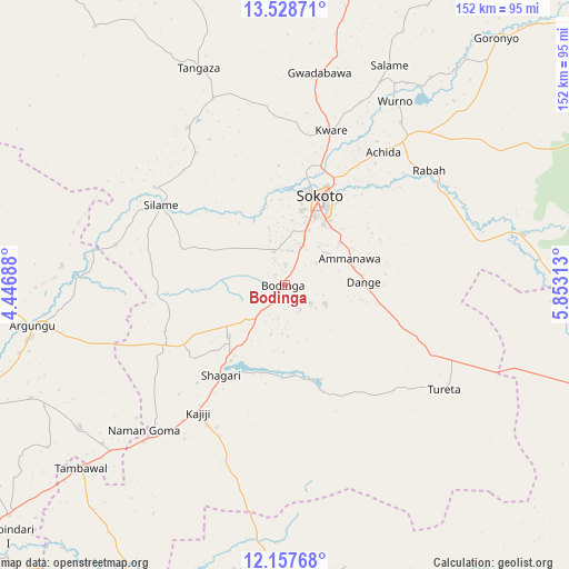
Bodinga GPS coordinates[2]
12° 50' 38.868" North, 5° 9' 0.036" East
| Map corner | latitude | longitude |
|---|---|---|
| Upper-left | 13.52871°, | 4.44688° |
| Center: | 12.84413°, | 5.15001° |
| Lower-right: | 12.15768°, | 5.85313° |
| Map W x H: | 152.4×152.4 km | = 94.7×94.7mi |
| max Lat: | 13.7543° ⇑4.9% North |
| Bodinga: | 12.84413° |
| min Lat: | ⇓95.1% South 4.31231° |
| min Long | Bodinga | max Long |
| 2.73333° | 5.15001° | 14.46552° |
| W 20.8%⇐ | ⇒79.2% E |
Elevation
Elevation of Bodinga is 302 m = 991 ft, and this is 5.5 m = 18 ft above average elevation for this country.
| Max E: |
1599 m = 5246 ft | 46.2% |
| Bodinga | 302 m 991 ft | |
| Avg. | 296.5 m = 973 ft | |
Min E: |
2 m = 7 ft | 53.8% |
See also: Nigeria elevation on elevation.city.
Geographical zone
Bodinga is located in North Torrid zone (between Equator and Tropic of Cancer). Distance of this Northern Tropic circle is 1177.8 km =731.9 mi to North.| Distance of | km | miles | from Bodinga |
|---|---|---|---|
| North Pole | 8578.9 | 5330.7 | to North |
| Arctic Circle | 5973 | 3711.4 | to North |
| Tropic Cancer | 1177.8 | 731.9 | to North |
| Equator | 1428.1 | 887.4 | to South |


Nearby cities:
15 places around Bodinga: (largest is in red/bold)
• Augie
59.9 km =37.2 mi,  274°
274°
• Binji
49.6 km =30.8 mi,  328°
328°
• Dange
21.2 km =13.2 mi,  87°
87°
• Gandi
65.7 km =40.8 mi,  78°
78°
• Gidan Madi
53.7 km =33.4 mi,  339°
339°
• Gwadabawa
57.9 km =36 mi,  9°
9°
• Kware
43.6 km =27.1 mi,  16°
16°
• Rabah
49.6 km =30.8 mi,  51°
51°
• Shagari
29.5 km =18.3 mi,  215°
215°
• Silame
39.5 km =24.5 mi,  303°
303°
• Sokoto
26.3 km =16.3 mi, 22°
• Tureta
51 km =31.7 mi,  123°
123°
• Wamako
21.3 km =13.2 mi,  346°
346°
• Wurno
57.8 km =35.9 mi,  30°
30°
• Yabo
20.1 km =12.5 mi,  227°
227°
Sources, notices
• [Note1] Compared only with cities in Nigeria existing in our database
• [Src1] Map data: © OpenStreetMap contributors (CC-BY-SA)
• [Src2] Other city data from geonames.org with taken over terms of usage.
• [Src3] Geographical zone / Annual Mean Temperature by Robert A. Rohde @ Wikipedia
