Rabah geodata
Rabah (Sokoto) is a seat of a second-order administrative division; located in Nigeria in Africa/Lagos (GMT+1) time zone. With population of 8,707 people, there are 363 cities with bigger population in this country. Compared to other cities in Nigeria, 98.2% of cities are located further ↓South; 75.8% of cities are located further →East and 52.8% of cities have higher elevation than Rabah. Note1


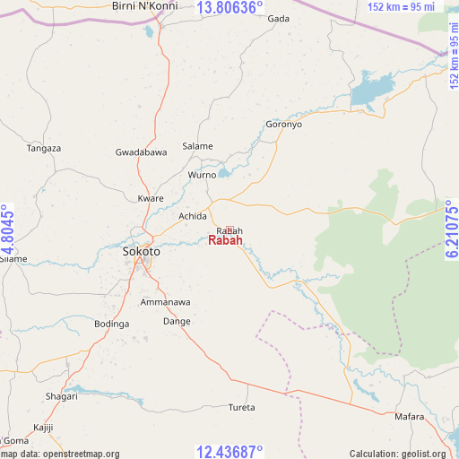
Rabah GPS coordinates[2]
13° 7' 21.252" North, 5° 30' 27.432" East
| Map corner | latitude | longitude |
|---|---|---|
| Upper-left | 13.80636°, | 4.8045° |
| Center: | 13.12257°, | 5.50762° |
| Lower-right: | 12.43687°, | 6.21075° |
| Map W x H: | 152.3×152.3 km | = 94.6×94.6mi |
| max Lat: | 13.7543° ⇑1.8% North |
| Rabah: | 13.12257° |
| min Lat: | ⇓98.2% South 4.31231° |
| min Long | Rabah | max Long |
| 2.73333° | 5.50762° | 14.46552° |
| W 24.2%⇐ | ⇒75.8% E |
Elevation
Elevation of Rabah is 265 m = 869 ft, and this is 31.5 m = 103 ft below average elevation for this country.
| Max E: |
1599 m = 5246 ft | 52.8% |
| Avg. | 296.5 m = 973 ft | |
| Rabah | 265 m = 869 ft | |
Min E: |
2 m = 7 ft | 47.2% |
See also: Nigeria elevation on elevation.city.
Geographical zone
Rabah is located in North Torrid zone (between Equator and Tropic of Cancer). Distance of this Northern Tropic circle is 1146.8 km =712.6 mi to North.| Distance of | km | miles | from Rabah |
|---|---|---|---|
| North Pole | 8548 | 5311.5 | to North |
| Arctic Circle | 5942.1 | 3692.2 | to North |
| Tropic Cancer | 1146.8 | 712.6 | to North |
| Equator | 1459.1 | 906.6 | to South |


Nearby cities:
15 places around Rabah: (largest is in red/bold)
• Bakura
60.5 km =37.6 mi,  139°
139°
• Binji
65.8 km =40.9 mi,  279°
279°
• Bodinga
49.6 km =30.8 mi,  231°
231°
• Dange
34.7 km =21.6 mi,  210°
210°
• Gandi
31.1 km =19.3 mi,  124°
124°
• Gidan Madi
60.8 km =37.8 mi,  288°
288°
• Goronyo
39.8 km =24.7 mi,  26°
26°
• Gwadabawa
39.2 km =24.4 mi,  311°
311°
• Illela
71.3 km =44.3 mi,  341°
341°
• Kware
28.3 km =17.6 mi, 292°
• Sokoto
29.4 km =18.3 mi,  256°
256°
• Tureta
58.9 km =36.6 mi,  176°
176°
• Wamako
44.9 km =27.9 mi, 256°
• Wurno
20.8 km =12.9 mi,  334°
334°
• Yabo
69.7 km =43.3 mi, 230°
Sources, notices
• [Note1] Compared only with cities in Nigeria existing in our database
• [Src1] Map data: © OpenStreetMap contributors (CC-BY-SA)
• [Src2] Other city data from geonames.org with taken over terms of usage.
• [Src3] Geographical zone / Annual Mean Temperature by Robert A. Rohde @ Wikipedia
