Shanono geodata
Shanono (Kano) is a seat of a second-order administrative division; located in Nigeria in Africa/Lagos (GMT+1) time zone. In our database, there are 451 cities with bigger population. Compared to other cities in Nigeria, 84.4% of cities are located further ↓South; 63.8% of cities are located further ←West and 92.3% of cities have lower elevation than Shanono. Note1


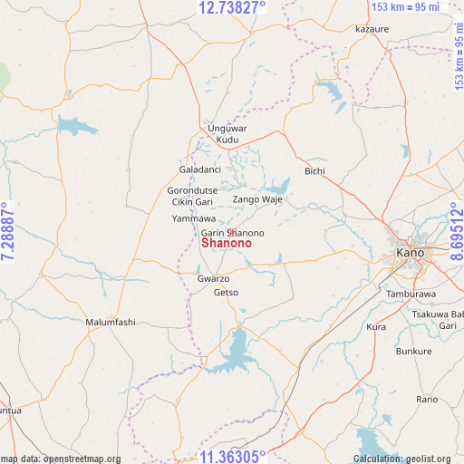
Shanono GPS coordinates[2]
12° 3' 5.544" North, 7° 59' 31.2" East
| Map corner | latitude | longitude |
|---|---|---|
| Upper-left | 12.73827°, | 7.28887° |
| Center: | 12.05154°, | 7.992° |
| Lower-right: | 11.36305°, | 8.69512° |
| Map W x H: | 152.9×152.9 km | = 95×95mi |
| max Lat: | 13.7543° ⇑15.6% North |
| Shanono: | 12.05154° |
| min Lat: | ⇓84.4% South 4.31231° |
| min Long | Shanono | max Long |
| 2.73333° | 7.992° | 14.46552° |
| W 63.8%⇐ | ⇒36.2% E |
Elevation
Elevation of Shanono is 584 m = 1916 ft, and this is 287.5 m = 943 ft above average elevation for this country.
| Max E: |
1599 m = 5246 ft | 7.7% |
| Shanono | 584 m 1916 ft | |
| Avg. | 296.5 m = 973 ft | |
Min E: |
2 m = 7 ft | 92.3% |
See also: Nigeria elevation on elevation.city.
Geographical zone
Shanono is located in North Torrid zone (between Equator and Tropic of Cancer). Distance of this Northern Tropic circle is 1265.9 km =786.6 mi to North.| Distance of | km | miles | from Shanono |
|---|---|---|---|
| North Pole | 8667.1 | 5385.5 | to North |
| Arctic Circle | 6061.2 | 3766.3 | to North |
| Tropic Cancer | 1265.9 | 786.6 | to North |
| Equator | 1340 | 832.6 | to South |


Nearby cities:
15 places around Shanono: (largest is in red/bold)
• Bagwai
19.6 km =12.2 mi,  52°
52°
• Bichi
33.8 km =21 mi, 53°
• Dawakin Tofa
37.2 km =23.1 mi,  80°
80°
• Gora
38.7 km =24 mi,  246°
246°
• Gwarzo
16.4 km =10.2 mi,  202°
202°
• Jikamshi
27.3 km =17 mi,  299°
299°
• Kabo
29.1 km =18.1 mi,  138°
138°
• Karaye
29.9 km =18.6 mi,  175°
175°
• Kiru
41.8 km =26 mi,  158°
158°
• Madobi
44.4 km =27.6 mi,  133°
133°
• Matazu
40.1 km =24.9 mi, 300°
• Musawa
36 km =22.4 mi,  283°
283°
• Rimin Gado
29.3 km =18.2 mi,  108°
108°
• Tofa
30.6 km =19 mi,  88°
88°
• Tsanyawa
27.1 km =16.8 mi,  358°
358°
Sources, notices
• [Note1] Compared only with cities in Nigeria existing in our database
• [Src1] Map data: © OpenStreetMap contributors (CC-BY-SA)
• [Src2] Other city data from geonames.org with taken over terms of usage.
• [Src3] Geographical zone / Annual Mean Temperature by Robert A. Rohde @ Wikipedia
