Upenekang geodata
Upenekang (Akwa Ibom) is a seat of a second-order administrative division; located in Nigeria in Africa/Lagos (GMT+1) time zone. In our database, there are 451 cities with bigger population. Compared to other cities in Nigeria, 99.2% of cities are located further ↑North; 63.3% of cities are located further ←West and 98.5% of cities have higher elevation than Upenekang. Note1


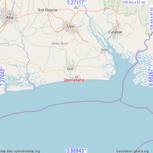
Upenekang GPS coordinates[2]
4° 34' 14.304" North, 7° 58' 46.38" East
| Map corner | latitude | longitude |
|---|---|---|
| Upper-left | 5.27117°, | 7.27642° |
| Center: | 4.57064°, | 7.97955° |
| Lower-right: | 3.86943°, | 8.68267° |
| Map W x H: | 155.9×155.9 km | = 96.9×96.9mi |
| max Lat: | 13.7543° ⇑99.2% North |
| Upenekang: | 4.57064° |
| min Lat: | ⇓0.8% South 4.31231° |
| min Long | Upenekang | max Long |
| 2.73333° | 7.97955° | 14.46552° |
| W 63.3%⇐ | ⇒36.7% E |
Elevation
Elevation of Upenekang is 7 m = 23 ft, and this is 289.5 m = 950 ft below average elevation for this country.
| Max E: |
1599 m = 5246 ft | 98.5% |
| Avg. | 296.5 m = 973 ft | |
| Upenekang | 7 m = 23 ft | |
Min E: |
2 m = 7 ft | 1.5% |
See also: Nigeria elevation on elevation.city.
Geographical zone
Upenekang is located in North Torrid zone (between Equator and Tropic of Cancer). Distance of Equator is 508.2 km =315.8 mi to South.| Distance of | km | miles | from Upenekang |
|---|---|---|---|
| North Pole | 9498.9 | 5902.3 | to North |
| Arctic Circle | 6893 | 4283.1 | to North |
| Tropic Cancer | 2097.7 | 1303.4 | to North |
| Equator | 508.2 | 315.8 | to South |


Nearby cities:
15 places around Upenekang: (largest is in red/bold)
• Abat
13.6 km =8.5 mi,  292°
292°
• Afaha Offiong
33.4 km =20.8 mi,  345°
345°
• Eket
10 km =6.2 mi,  322°
322°
• Enwang
31.7 km =19.7 mi,  72°
72°
• Etinan
33.4 km =20.8 mi,  335°
335°
• Eyofin
34.3 km =21.3 mi,  54°
54°
• Ikot Edibon
22.8 km =14.2 mi, 346°
• Mkpat Enin
31.4 km =19.5 mi,  305°
305°
• Nung Udoe
38.5 km =23.9 mi,  357°
357°
• Odot
29.7 km =18.5 mi,  12°
12°
• Okopedi
34.9 km =21.7 mi,  27°
27°
• Okoroete
25.8 km =16 mi,  262°
262°
• Oron
39.8 km =24.7 mi, 45°
• Uquo
13.1 km =8.1 mi,  41°
41°
• Urue Offong
29.1 km =18.1 mi, 45°
Sources, notices
• [Note1] Compared only with cities in Nigeria existing in our database
• [Src1] Map data: © OpenStreetMap contributors (CC-BY-SA)
• [Src2] Other city data from geonames.org with taken over terms of usage.
• [Src3] Geographical zone / Annual Mean Temperature by Robert A. Rohde @ Wikipedia
