Abat geodata
Abat (Akwa Ibom) is a seat of a second-order administrative division; located in Nigeria in Africa/Lagos (GMT+1) time zone. In our database, there are 451 cities with bigger population. Compared to other cities in Nigeria, 99.1% of cities are located further ↑North; 60.9% of cities are located further ←West and 91.6% of cities have higher elevation than Abat. Note1


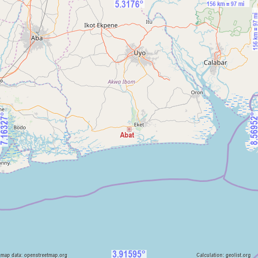
Abat GPS coordinates[2]
4° 37' 1.632" North, 7° 51' 59.004" East
| Map corner | latitude | longitude |
|---|---|---|
| Upper-left | 5.3176°, | 7.16327° |
| Center: | 4.61712°, | 7.86639° |
| Lower-right: | 3.91595°, | 8.56952° |
| Map W x H: | 155.8×155.9 km | = 96.8×96.9mi |
| max Lat: | 13.7543° ⇑99.1% North |
| Abat: | 4.61712° |
| min Lat: | ⇓0.9% South 4.31231° |
| min Long | Abat | max Long |
| 2.73333° | 7.86639° | 14.46552° |
| W 60.9%⇐ | ⇒39.1% E |
Elevation
Elevation of Abat is 23 m = 75 ft, and this is 273.5 m = 897 ft below average elevation for this country.
| Max E: |
1599 m = 5246 ft | 91.6% |
| Avg. | 296.5 m = 973 ft | |
| Abat | 23 m = 75 ft | |
Min E: |
2 m = 7 ft | 8.4% |
See also: Nigeria elevation on elevation.city.
Geographical zone
Abat is located in North Torrid zone (between Equator and Tropic of Cancer). Distance of Equator is 513.4 km =319 mi to South.| Distance of | km | miles | from Abat |
|---|---|---|---|
| North Pole | 9493.7 | 5899.1 | to North |
| Arctic Circle | 6887.8 | 4279.9 | to North |
| Tropic Cancer | 2092.5 | 1300.2 | to North |
| Equator | 513.4 | 319 | to South |


Nearby cities:
15 places around Abat: (largest is in red/bold)
• Afaha Offiong
27.6 km =17.1 mi,  9°
9°
• Eket
7 km =4.3 mi,  66°
66°
• Etinan
25.1 km =15.6 mi,  356°
356°
• Ikot Abasi
35.2 km =21.9 mi,  261°
261°
• Ikot Edibon
18.5 km =11.5 mi,  22°
22°
• Ikot Ibritam
35.4 km =22 mi,  307°
307°
• Mkpat Enin
18.5 km =11.5 mi,  315°
315°
• Nung Udoe
35 km =21.7 mi, 17°
• Odot
30.5 km =19 mi,  38°
38°
• Okopedi
38.6 km =24 mi,  48°
48°
• Okoroete
15.6 km =9.7 mi,  236°
236°
• Opobo
38.2 km =23.7 mi,  252°
252°
• Upenekang
13.6 km =8.5 mi,  112°
112°
• Uquo
21.8 km =13.5 mi,  77°
77°
• Urue Offong
36.6 km =22.7 mi, 65°
Sources, notices
• [Note1] Compared only with cities in Nigeria existing in our database
• [Src1] Map data: © OpenStreetMap contributors (CC-BY-SA)
• [Src2] Other city data from geonames.org with taken over terms of usage.
• [Src3] Geographical zone / Annual Mean Temperature by Robert A. Rohde @ Wikipedia
