Okopedi geodata
Okopedi (Akwa Ibom) is a seat of a second-order administrative division; located in Nigeria in Africa/Lagos (GMT+1) time zone. In our database, there are 451 cities with bigger population. Compared to other cities in Nigeria, 95.9% of cities are located further ↑North; 65.5% of cities are located further ←West and 87.2% of cities have higher elevation than Okopedi. Note1


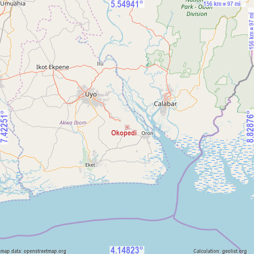
Okopedi GPS coordinates[2]
4° 50' 57.048" North, 8° 7' 32.304" East
| Map corner | latitude | longitude |
|---|---|---|
| Upper-left | 5.54941°, | 7.42251° |
| Center: | 4.84918°, | 8.12564° |
| Lower-right: | 4.14823°, | 8.82876° |
| Map W x H: | 155.8×155.8 km | = 96.8×96.8mi |
| max Lat: | 13.7543° ⇑95.9% North |
| Okopedi: | 4.84918° |
| min Lat: | ⇓4.1% South 4.31231° |
| min Long | Okopedi | max Long |
| 2.73333° | 8.12564° | 14.46552° |
| W 65.5%⇐ | ⇒34.5% E |
Elevation
Elevation of Okopedi is 49 m = 161 ft, and this is 247.5 m = 812 ft below average elevation for this country.
| Max E: |
1599 m = 5246 ft | 87.2% |
| Avg. | 296.5 m = 973 ft | |
| Okopedi | 49 m = 161 ft | |
Min E: |
2 m = 7 ft | 12.8% |
See also: Nigeria elevation on elevation.city.
Geographical zone
Okopedi is located in North Torrid zone (between Equator and Tropic of Cancer). Distance of Equator is 539.2 km =335 mi to South.| Distance of | km | miles | from Okopedi |
|---|---|---|---|
| North Pole | 9467.9 | 5883.1 | to North |
| Arctic Circle | 6862 | 4263.8 | to North |
| Tropic Cancer | 2066.7 | 1284.2 | to North |
| Equator | 539.2 | 335 | to South |


Nearby cities:
15 places around Okopedi: (largest is in red/bold)
• Afaha Offiong
24.3 km =15.1 mi,  273°
273°
• Akankpa
31.6 km =19.6 mi,  12°
12°
• Calabar
25.4 km =15.8 mi,  61°
61°
• Enwang
25.6 km =15.9 mi,  146°
146°
• Esuk Oron
15.1 km =9.4 mi,  109°
109°
• Etinan
30.3 km =18.8 mi, 268°
• Eyofin
15.9 km =9.9 mi,  133°
133°
• Idu
23.4 km =14.5 mi,  329°
329°
• Ikot Edibon
23.3 km =14.5 mi,  247°
247°
• Nung Udoe
19.5 km =12.1 mi,  292°
292°
• Odot
9.9 km =6.2 mi,  258°
258°
• Oron
12.5 km =7.8 mi,  104°
104°
• Uquo
22.5 km =14 mi,  199°
199°
• Urue Offong
11.7 km =7.3 mi,  156°
156°
• Uyo
31 km =19.3 mi,  316°
316°
Sources, notices
• [Note1] Compared only with cities in Nigeria existing in our database
• [Src1] Map data: © OpenStreetMap contributors (CC-BY-SA)
• [Src2] Other city data from geonames.org with taken over terms of usage.
• [Src3] Geographical zone / Annual Mean Temperature by Robert A. Rohde @ Wikipedia
